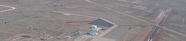
The second permanent launch site of the NASA balloon program is the Scientific Balloon Flight Facility located inside the boundaries of the Fort Sumner Municipal Airport on the northeast side of the town. Ft. Sumner is about 3 hours drive east and a bit south of Albuquerque, in De Baca county, New Mexico .
The airport was established in the 1920's when the Transcontinental Air Transport company built it as part of its coast-to-coast air passenger network. It was abandoned after the company's plan collapsed during the Great Depression being reopened ten years after by the Army Air Corps which used it as training base during the World War II. After the war the airport and facilities were transferred to the town of Fort Sumner under which control still remains today, serving for operations of small private planes. A very large hanger, two runways, and a large apron area were the primary assets of the airport.

In 1985, the NASA balloon program made a flight safety analysis, identifying a significant risk associated with balloon flights launched at Palestine, and traversing to the east. The primary safety issue was a balloon failure occurring during ascent in the area around Palestine, along with a minor hazard in the planned impact zone of the more densely populated areas to the east. As a result, additional safety requirements were imposed on turnaround and easterly flights of heavy payloads (exceeding 1,600 kilograms). At the same time, a survey was performed in 1986 to identify a new semi-permanent western launch location resulting in the selection for the first time of Fort Sumner as an acceptable site for balloon operations. The only setbacks were related to the surrounding landscape. Fort Sumner is at 4,000 feet altitude in a desert environment, and is subject to a lot of low level winds during the night and during the days in the spring time. One of the reasons that NSBF first chose Fort Sumner was because the presence of the large old World War II airplane hanger that could be used for payload assembly and checkout. The first balloon launch was conducted there in March 1986 while UCAR was the manager of the NSBF. A leased crane was used as a payload launch vehicle.
In the late 1980s, NASA spent about $100.000 to construct large insulated walls and air conditioning inside the hanger so payloads could use the place in a controlled environment. Three bays with tall sliding doors that opened into the main hanger area provided a workable area for scientists and their payloads with large steel A-frames used to suspend the payloads. Another flight safety risk analysis performed in 1988 resulted in performing all stratospheric turnaround balloon flights from Ft. Sumner rather than Palestine. The safety risk associated with stratospheric turnaround flights going toward Houston, TX and other populated areas to the south became unacceptable by NASA.
This forced CSBF to adopt a new operational approach within the NASA Balloon Program using Palestine, as the principal center for scientific ballooning, but only for missions traversing to the west. Ft. Sumner, NM became the primary candidate as a permanent alternate launch site to meet easterly and turnaround flight requirements: where payloads could be impacted in moderate to low population density areas but offering a high probability for recovery. These safety conditions ruled out automatically all areas east of the Mississippi River due to high population issues. Thus the only part of the country which fulfilled the safety and operational requirements was the southwestern area of the US.
A detailed survey was conducted over New Mexico, Arizona, and southern Nevada and 30 candidate sites were identified. A comprehensive study was performed on these places giving consideration to various factors including safety, geography, air traffic activity, meteorology, and existing facilities. Art Gilcrease was the person in charge of that study. He did an exhaustive study for alternate sites and in December 1988 the studys concluded that Fort Sumner was the best location. The site not only best met the selection criteria but offered the advantage of being complementary to the Palestine Base, from the standpoint of downrange tracking and staging of recovery forces.
Infrastructure and Facilities
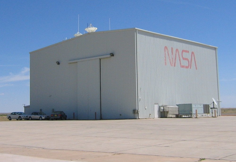
Immediately an extensive effort was made to build permanent facilities there. The large NASA High Bay building was approved for construction by NASA in the early 1990s but the agency first had to purchase the land at the airport from the city of Fort Sumner since the US federal government cannot build facilities on land not owned by the government. It took a couple of years to complete that transaction.
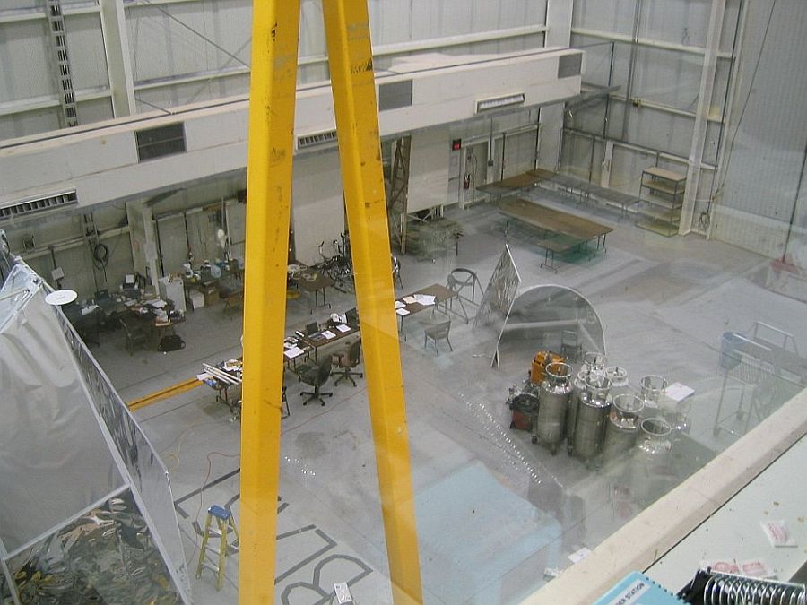
The building is a 12.2 meter high-bay with over 600 square meters of air conditioned floor area that is used to check and integrate up to four scientific payloads at a time and provide work areas for operations and support personnel. Inside the building structure a 4500 kg monorail crane is used to move gondolas and equipment between two 9.1 meter high doors on either ends of the building.
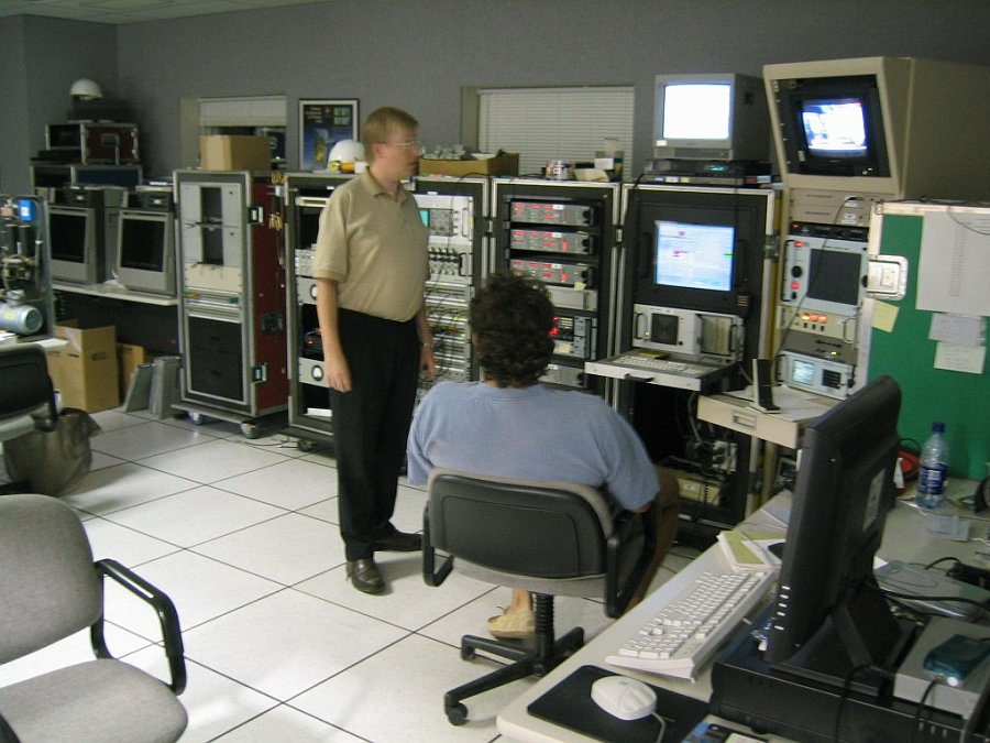
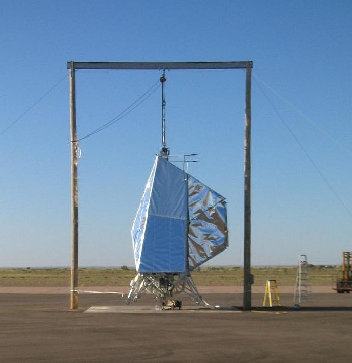
The second phase of construction of the high bay was completed in mid 1994 with the addition of paved areas around the building, and the completion of a second and third floor with enclosed telemetry station, weather station, and a complete flight control center. A roof platform was added to serve as mounting structure for line-of-sight telemetry antennas and in recent years to mount two cameras allowing to follow the balloon launch operations through the internet. Near the main building, a non-magnetic frame (which some people know as the "Pi" frame) is used to calibrate the magnetic sensors on balloon payloads.
Since the completion of the Fort Sumner base, the operational concept for routine support of line-of-sight zero pressure balloon flights in the Continental US has been stratospheric turn-around flights there, and flights traveling west from Palestine in the summer. Pre and Post-turnaround flights from Fort Sumner are supported using Palestine as a downrange station for easterly going flights while a mobile telemetry station is located at the Winzlow airport in Arizona when the balloons are heading due west.
The first launches were performed using a rented crane with outriggers on to keep it from tipping over to the side. Then NSBF owned a 35 ton crane that was used for a long time, but during a balloon launch under heavy wind the front end of the crane was lifted off the ground and turned the crane about 90 degrees. Taking account that these cranes were not very easy to use for balloon launches, the need for a specially made transportable launch vehicle to handle payloads soon become evident. The large NSBF based payload launch vehicle, "Tiny Tim", was not able to be moved outside Palestine due to its extremely wide wheelbase and inability to be easily disassembled. This limitation resulted in the design and construction of the Mobile Launch Vehicle (MLV).

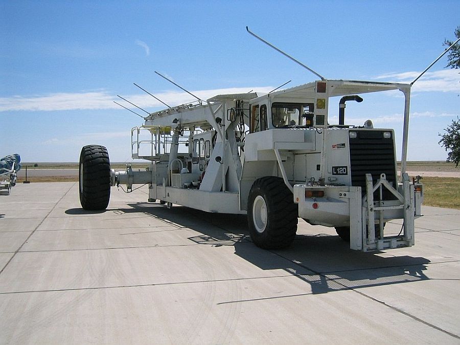
The MLV was designed and fabricated by the engineers and technicians at New Mexico State University in Las Cruces. They tried to award a contract to build the vehicle commercially, but they could not get acceptable bids from the big companies so they decided to build it within their own organization, with NASA approval. As they had a shop in Las Cruces that had been building trailers and vans for instrumentation/telemetry jobs they were confident on the task.
The MLV is basically the motor and drive wheel unit from a Michigan brand large articulated front end loader. The part of the MLV in front of the articulation point used the articulation hardware from the original machine with the specially designed structure and boom with a 24 foot wheelbase and solid foam filled wheels that could be removed for transportation.
The vehicle is transportable however it is used primarily at the Fort Sumner facility where it provides heavy lift payload capabilities. It has two configurations, one for transporting on the highway, the other for launch. Transition from road configuration to launch configuration can be accomplished by four people in four hours, with the reverse taking six hours. In its launch configuration, the vehicle weighs over 50 tons, measures approximately 13 meters in length and 7 meters in width at its widest point, and has a launch boom that can be raised about 12 meters above the ground.
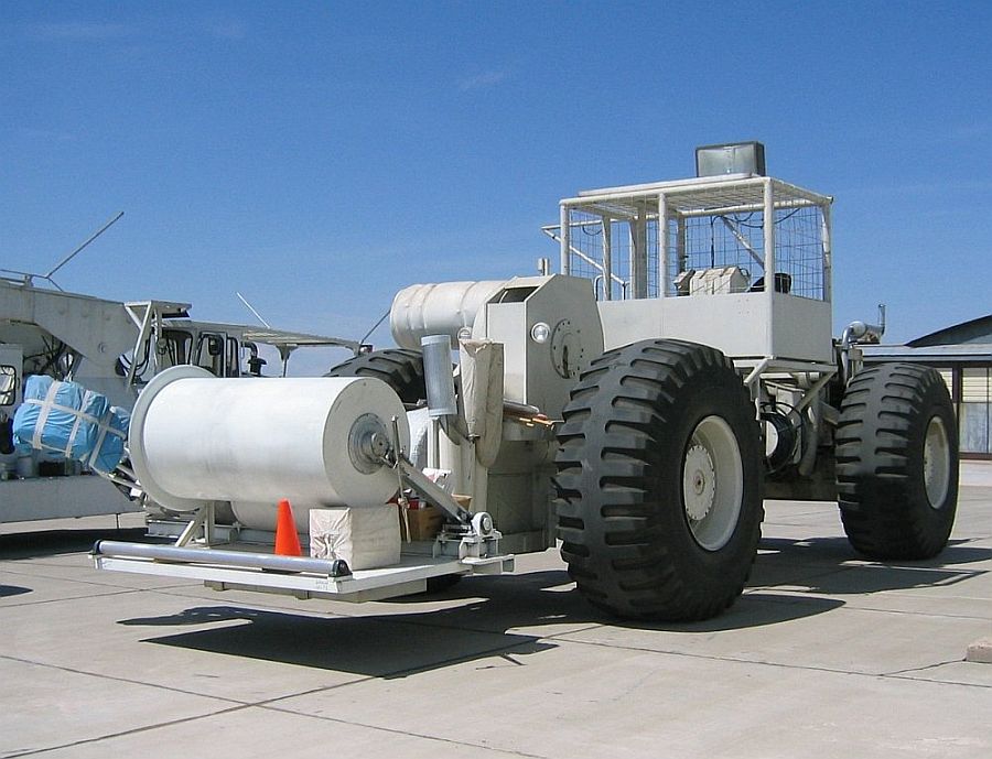
This unique, one-of-a-kind, vehicle was delivered to Fort Sumner in 1991 and was declared operational during the Fall campaign the next year. It is used along with a spool mounted in a large bulldozer type vehicle which holds the semi-inflated balloon at launch time. The dynamic launch capabilities of the MLV are for balloons with a gross inflation of 6727 kilograms while the suspended load is in the order of 3636 kilograms.
After a while, the MLV was renamed as "Big Bill" after the nick name for Bill Harrison, one of the NSBF mechanical technicians who grew up in Palestine and started working at the balloon base when he was young. He was the primary driver of Tiny Tim and also the Mobile Launch Vehicle (MLV) and a very appreciated member of the program staff.
Current two operational balloon launch campaigns are conducted at Ft. Sumner, NM each year. These occur in the May-June and September-October timeframe surrounding the two stratospheric turnaround events. The NASA Ft. Sumner facility has grown in capability over the years and now includes a machine shop and still utilizes the old World War II hanger as a work area, storage area for support vehicles, and a hanger for NSBF aircraft during balloon flight operations.
Table of balloons launched from Fort Sumner
| Date | Hour | Flight Duration | Experiment | Payload landing place or cause of the failure |
|---|---|---|---|---|
| 3/2/1987 | 16:15 utc | 4 h 30 m | BALLOON MATERIAL TEST | 20 miles N of Lawton, Oklahoma, US |
| 3/6/1987 | 14:29 utc | --- | BALLOON MATERIAL TEST | 3 miles W of Ralls, Texas, US |
| 4/2/1987 | 22:28 utc | --- | 102 CM FAR INFRARED TELESCOPE | 15 miles NW of Waco, Texas, US |
| 5/8/1987 | 19:31 utc | --- | GAMMA RAY EXPERIMENT | 18 miles N of Fort Sumner, New Mexico, US |
| 11/18/1987 | 20:10 utc | 4 h 27 m | HIGH RESOLUTION INTERFEROMETER | 23 miles SW of Ardmore, Oklahoma, US |
| 12/3/1987 | 18:40 utc | 3 h 10 m | SF-372 MATERIAL TEST | 21 miles SW of Guthrie, Texas, US |
| 12/9/1987 | 16:19 utc | 4 h 10 m | SF-372 MATERIAL TEST | 9 miles W of Haskell, Texas, US |
| 2/11/1988 | 16:23 utc | --- | SF-372 MATERIAL TEST | 7 miles NW of Texico, Texas, US |
| 9/30/1988 | 14:54 utc | --- | BMLS (Balloon-borne Microwave Limb Sounder) | 20 miles NW of Carrizozo, New Mexico, US |
| 10/8/1988 | 23:37 utc | --- | EXITE-1 (Energetic X-Ray Imaging Telescope Experiment) | 24 miles SSW of Wichita Falls, Texas, US |
| 10/17/1988 | 00:00 utc | --- | MIT RADIOMETER | 27 miles S of Amarillo, Texas, US |
| 10/26/1988 | 14:12 utc | --- | SDS (Solar Disk Sextant) | 19 miles NW of McAllister, US |
| 4/18/1989 | 11:54 utc | --- | SDS (Solar Disk Sextant) | 7 miles N of Onley, Texas, US |
| 4/19/1989 | 21:19 utc | --- | HIGH RESOLUTION INTERFEROMETER | 13 miles E of Dimmit, Texas, US |
| 9/26/1989 | 14:16 utc | 23 h | JPL OMS Gondola (BMLS + FIRS-2) | 11 miles NW of Gallup, New Mexico, US |
| 9/29/1989 | 0:47 utc | --- | COMPTON GAMMA RAY TELESCOPE | 2 miles S of Des Moines, New Mexico, US |
| 10/6/1989 | 23:31 utc | --- | MIT RADIOMETER | 30 miles SW of Hobart, Oklahoma, US |
| 10/8/1989 | 15:41 utc | --- | UV O3 PHOTOMETER | 5 miles NE of Hobart, Oklahoma, US |
| 10/13/1989 | 15:53 utc | 5 h | BALLOON STRESS INDEX TEST #1 | 12 miles NNW of Plainview, Texas, US |
| 10/19/1989 | 22:50 utc | --- | COSMIC RAY EXPERIMENT | 6 Nm E Jayton, Texas, US |
| 10/24/1989 | 13:39 utc | --- | CRYOGENIC AIR COLLECTOR | 50 miles ENE of Plainview, Texas, US |
| 11/2/1989 | 16:12 utc | --- | TEST OF NEW BALLOON | 20 miles W of Childress, Texas, US |
| 11/9/1989 | --- | PAYLOAD UNKNOWN | Aborted flight | |
| 11/15/1989 | 23:13 utc | --- | MAX (Millimeter wavelength Anisotropy eXperiment) | 30 miles SE of Roswell, New Mexico, US |
| 11/18/1989 | 0:59 utc | --- | INFRARED EXPERIMENT | 20 miles SE of Clovis, New Mexico, US |
| 5/4/1990 | 14:27 utc | --- | SDS (Solar Disk Sextant) | 15 miles W of Sayre, Oklahoma, US |
| 5/5/1990 | 13:56 utc | 7 h | BALLOON STRESS INDEX TEST #2 | 10 miles W of Tulia, Texas, US |
| 5/12/1990 | 14:32 utc | --- | UV O3 PHOTOMETER | 8 miles W of Dimmit, Texas, US |
| 5/21/1990 | --- | PAYLOAD UNKNOWN | Aborted flight | |
| 5/31/1990 | 13:09 utc | 21 h | GRIS (Gamma-Ray Imaging Spectrometer) | 5 miles NE of Show Low, Arizona, US |
| 6/4/1990 | 13:40 utc | 28 h | FIRS-2 (far infrared Fourier transform spectrometer) / UV O3 PHOTOMETER | 22 miles NW of Prescott, Arizona, US |
| 7/10/1990 | 14:07 utc | 4 h | BALLOON STRESS INDEX TEST #3 | 8 miles S of Belen, New Mexico, US |
| 7/28/1990 | 15:15 utc | 4 h | BALLOON STRESS INDEX TEST #4 | 9 miles NW of Corona, New Mexico, US |
| 9/19/1990 | 14:43 utc | --- | ATMOSPHERIC SCIENCES | 10 miles NNW of Roswell, New Mexico, US |
| 9/26/1990 | 0:43 utc | F 44 h | JACEE 9 (Japanese-American Collaborative Emulsion Experiment) | 13 miles NW of Olathe, Kansas, US |
| 9/27/1990 | 15:06 utc | --- | MKIV INTERFEROMETER + UV O3 PHOTOMETER | 47 miles ESE of Childress, Texas, US |
| 10/9/1990 | 16:06 utc | --- | IBEX (Infrared Balloon-Borne Experiment) | 10 miles NE of Seymour, Texas, US |
| 10/11/1990 | 14:06 utc | --- | SDS (Solar Disk Sextant) | 13 miles S of Shawnee, Oklahoma, US |
| 10/23/1990 | 23:48 utc | --- | ATMOSPHERIC SCIENCES | 17 miles E of Lockney, Texas, US |
| 10/28/1990 | 14:45 utc | --- | SUPERPRESSURE BALLOON | 10 miles S of Fort Sumner, New Mexico, US |
| 10/30/1990 | 14:53 utc | --- | ELBBO (Extended Life Balloon Borne Observatories Program) | 4.5 miles NW of Kenna, New Mexico, US |
| 1/30/1991 | 15:25 utc | --- | LONG DURATION BALLOON | 18 miles S of Roswell, New Mexico, US |
| 3/29/1991 | 15:05 utc | 5 h | BALLOON STRESS INDEX TEST #5 | 14 miles ESE of Childress, Texas, US |
| 3/31/1991 | 13:05 utc | --- | IN SITU ClO MEASUREMENTS | 20 Miles S of Texico, New Mexico, US |
| 5/5/1991 | 14:03 utc | --- | MKIV INTERFEROMETER | 12 miles SW of Grants, New Mexico, US |
| 5/8/1991 | 13:13 utc | 7 h | BALLOON STRESS INDEX TEST #6 | 23 miles ENE of Roswell, New Mexico, US |
| 6/16/1991 | 13:30 utc | --- | LONG DURATION BALLOON | 40 miles NNE of Truth or Consequences, New Mexico, US |
| 6/18/1991 | 14:07 utc | --- | NSP TEST (?) | Balloon failure. Payload landed 9 miles SW of Melrose, Texas, US |
| 9/17/1991 | 13:54 utc | --- | CRYOGENIC AIR COLLECTOR | 5 miles N of Lidia, New Mexico, US |
| 9/23/1991 | 14:00 utc | 23 h | MASS (Matter Antimatter Superconducting Spectrometer) | 23 miles W of Corona, New Mexico, US |
| 9/25/1991 | 15:40 utc | 30 h | RICH (Ring Imaging Cerenkov Counter) | 15 miles W of Newman, Texas, US |
| 10/1/1991 | 8:53 utc | --- | UV O3 PHOTOMETER | 37 miles SE of Liberal, Kansas, US |
| 11/8/1991 | 8:52 utc | --- | ATMOSPHERIC SCIENCES | 10 miles W of Pauls valley, Oklahoma, US |
| 5/4/1992 | 12:46 utc | --- | HIGH RESOLUTION IR SOLAR OBSERVATION | 15 Miles NW of Childress, Texas, US |
| 5/4/1992 | 11:04 utc | --- | IBEX (Infrared Balloon-Borne Experiment) | 10 Miles NW of Monihans, Texas, US |
| 5/29/1992 | 13:13 utc | --- | FIRS-2 (far infrared Fourier transform spectrometer) + UV O3 PHOTOMETER | 18 miles S of Gallup, New Mexico, US |
| 9/14/1992 | 13:30 utc | --- | MKIV INTERFEROMETER | 39 miles NE of Holzbrook, Arizona, US |
| 9/22/1992 | --- | PAYLOAD UNKNOWN | Aborted launch | |
| 9/29/1992 | 13:56 utc | 8 h | FIRS-2 (far infrared Fourier transform spectrometer) + UV O3 PHOTOMETER | 14 miles WSW of Canadian, Texas, US |
| 9/30/1992 | 12:58 utc | ~ 10 h | SDS (Solar Disk Sextant) | 13 miles SW of Quanah, Texas, US |
| 10/16/1992 | 21:11 utc | --- | SCRIBE (Stratospheric Cryogenic Interferometer Balloon Experiment) | 50 miles ESE of Plainview, Texas, US |
| 11/5/1992 | 14:08 utc | --- | CLC PARACHUTE TEST | 5 miles S of Clarendon, Texas, US |
| 5/3/1993 | 14:34 utc | --- | 8000# PAYLOAD TEST FLIGHT | 15 miles E of Guthrie, Texas, US |
| 5/25/1993 | --- | PAYLOAD UNKNOWN | Aborted flight | |
| 5/31/1993 | 12:15 utc | --- | IBEX (Infrared Balloon-Borne Experiment) | 20 miles W of Belen, New Mexico, US |
| 6/11/1993 | 14:50 utc | --- | HIGH RESOLUTION IR SOLAR OBSERVATION | 20 miles S of Pueblo, New Mexico, US |
| 9/1/1993 | --- | PAYLOAD UNKNOWN | Aborted flight | |
| 9/8/1993 | 00:32 utc | ~ 25 h | TS93 | 2 miles W of Eloy, Arizona, US |
| 9/14/1993 | 23:08 utc | 37 h 30 m | GRIP-2 (Gamma-Ray Imaging Payload) | 25 miles NE of Lake Havasu, Arizona, US |
| 9/23/1993 | 14:10 utc | 24 h | GRIS (Gamma-Ray Imaging Spectrometer) | 5 miles SE of Hobart, Oklahoma, US |
| 9/25/1993 | 17:54 utc | --- | MKIV INTERFEROMETER + UV O3 PHOTOMETER | 23 miles SE of Abilene, Texas, US |
| 9/29/1993 | 17:37 utc | ~ 24 h | BUGS-4 (Bristol University Gas Scintillator) | 10 miles SE of Woodward, Oklahoma, US |
| 10/11/1993 | --- | PAYLOAD UNKNOWN | Aborted flight | |
| 10/27/1993 | 13:38 utc | --- | BLIMP (Balloon Launched INTEGRAL Model Payload) | 3 miles NE of Gotebo, Oklahoma, US |
| 1/23/1994 | 15:17 utc | 11 h | FGE (Flare Genesis Experiment) | 3 miles SE of Paducah, Texas, US |
| 5/3/1994 | 13:13 utc | F 26 h | HEAT (High-Energy Antimatter Telescope) | 6 miles W of Wellington, Texas, US |
| 5/15/1994 | 12:37 utc | --- | IBEX (Infrared Balloon-borne EXperiment) | 35 miles W of Pueblo, Colorado, US |
| 5/22/1994 | 14:29 utc | 22 h | MKIV INTERFEROMETER + FIRS-2 (far infrared Fourier transform spectrometer) + UV O3 PHOTOMETER | 8 miles SW of Datil, New Mexico, US |
| 9/17/1994 | 8:15 local | 32 h | PRONAOS (Projet National d'Astronomie Submillimetrique) | 25 miles SE of Gallup, New Mexico, US |
| 9/26/1994 | 13:01:50 | ~ 10 h | SDS (Solar Disk Sextant) | 15 miles N of Clovis, New Mexico, US |
| 10/9/1994 | 07:57:34 | --- | UV O3 PHOTOMETER | 20 miles SE of Childress, Texas, US |
| 10/19/1994 | 15:53:21 | --- | 8000# PAYLOAD TEST FLIGHT | 10 miles N of Elk City, Oklahoma, US |
| 4/1/1995 | 13:28 utc | --- | LONG DURATION BALLOON | 22 miles SE of Corona, New Mexico, US |
| 9/27/1995 | 12:56 utc | 20 h | SUPER-JACEE (Japanese-American Collaborative Emulsion Experiment) | 8 miles S of Medicine Lodge, Kansas, US |
| 9/28/1995 | 10:49 utc | 11 h | SOFCAL (Scintillating Optical Fiber Calorimeter) | 33miles SW of Guymon, Oklahoma, US |
| 10/1/1995 | 12:48 utc | 10 h | SDS (Solar Disk Sextant) | 5 miles NNW of San Jon, Nuevo Mexico, US |
| 10/6/1995 | 15:11 utc | 14 h 30 m | LAPEX (Large-Area Phoswich balloon Experiment for hard-X-ray astronomy) | 22 miles ESE of Roswell, Nuevo Mexico, US |
| 10/10/1995 | 8:22 utc | 9 h 30 m | UPPER ATMOSPHERE RESEARCH | 5 miles W of Haskell, Texas, US |
| 10/14/1995 | 13:37 utc | 8 h | HIGH ENERGY ASTROPHYSICS | 17 miles NW of Wichita Falls, Texas, US |
| 12/9/1995 | 23:35 utc | 8 h | XPER (X band Experiment) | 20 miles SSO of Lawton, Oklahoma, US |
| 2/2/1996 | --- | HACME (HEMT Advanced Cosmic Microwave Explorer) | Aborted flight | |
| 2/11/1996 | 22:55 utc | 21 h | HACME (HEMT Advanced Cosmic Microwave Explorer) | 20 miles NE of Prescott, Arizona, US |
| 6/2/1996 | 00:17 utc | 5 h 10 m | HACME (HEMT Advanced Cosmic Microwave Explorer) | Balloon failure at 80.000 ft. Landing 3 miles NE of Taiban, Nuevo Mexico, US |
| 6/10/1996 | 15:23 utc | 5 h | ALIAS II + LACE (Lightweight Airborne Chromatograph Experiment) + UV O3 PHOTOMETER + ARGUS | 13 miles E of Corona, Nuevo Mexico, US |
| 9/21/1996 | 13:14 utc | 5 hr | ALIAS II + UV O3 PHOTOMETER + ARGUS | 5 miles N of Dora, Nuevo Mexico, US |
| 9/22/1996 | 12:41 utc | 33 h | PRONAOS (Projet National d'Astronomie Submillimetrique) | 5 miles E of Pastura, New Mexico, US |
| 9/28/1996 | 14:13 utc | 15 h | MKIV INTERFEROMETER | 15 miles N of Lordsburg, New Mexico, US |
| 10/10/1996 | 13:29 utc | 10 h 50 m | SDS (Solar Disk Sextant) | 6 miles of Afton, Texas, US |
| 10/13/1996 | 16:27 utc | 9 h 30 m | COSMIC AND HELIOSPHERIC PHYSICS | 9 miles N of Elk City, Oklahoma, US |
| 10/23/1996 | 15:00 utc | --- | SOLAR CELL CALIBRATION | Flight aborted |
| 11/8/1996 | 14 h 30 m | QMAP | 10 miles of Shamrock, Texas, US | |
| 3/30/1997 | 15:28 utc | 10 h | TEST FLIGHT | 8 miles N of Mountainair, New Mexico, US |
| 5/7/1997 | 16:16 utc | 18 h 30 m | EXITE-2 (Energetic X-Ray Imaging Telescope Experiment) + MIXE-2 (Marshall Imaging X-ray Experiment) | W Oklahoma City, US |
| 5/20/1997 | 13:43 utc | 26 h | SOFCAL (Scintillating Optical Fiber Calorimeter) | 14 miles SW of Congress, Arizona, US |
| 5/24/1997 | 13:24 utc | 5 h | CAPRICE 2 (Cosmic AntiParticle Ring Imaging Cherenkov) | 13 miles of Corona, New Mexico, US |
| 9/20/1997 | --- | COSMIC AND HELIOSPHERIC PHYSICS | --- No Data --- | |
| 9/24/1997 | 14:04 utc | 26 h 50 m | TIGER (Trans-Iron Galactic Element Recorder) | 8 miles SE of Coldwater, Kansas, US |
| 10/4/1997 | 16:25 utc | 21 h | RICH II (Ring Imaging Cerenkov Detector) | 11 miles W of Apache, Oklahoma, US |
| 10/15/1997 | 12:43 utc | 7 h 50 m | HEXIS (High Energy X-ray Imaging Spectrometer) | W of Wichita Falls, Texas, US |
| 3/20/1998 | 23:11:28 | --- | TEST FLIGHT | 3 miles S of Roaring Springs, Texas, US |
| 4/9/1998 | 12:35:49 | --- | TEST FLIGHT | 12 miles W of Electra, Texas, US |
| 4/22/1998 | 2:01 utc | 6 h 30 m | BACH (Balloon Air Cherenkov) | 15 miles SSE of Sweetwater, Texas, US |
| 5/16/1998 | 12:42 utc | 1 h 30 m | CAPRICE 2 (Cosmic AntiParticle Ring Imaging Cherenkov) | Balloon failure. Payload landed 2.6 miles SE of Ragland, New Mexico, US |
| 5/18/1998 | 13:18:21 | --- | OMS Gondola (ALIAS II + UV O3 PHOTOMETER + ARGUS) | 6 miles NE of Glenrip, New Mexico, US |
| 5/21/1998 | 12:34:13 | 22 h | HEXIS (High Energy X-ray Imaging Spectrometer) | 15 miles SE of Claude, Texas, US |
| 5/24/1998 | 12:32:06 | --- | HETERODYNE RADIOMETER | 20 miles NE of Santa Rosa, New Mexico, US |
| 5/28/1998 | 14:13 utc | 20 h | CAPRICE 2 (Cosmic AntiParticle Ring Imaging Cherenkov) | 15 miles N of Heber, Arizona, US |
| 9/28/1998 | 16:21 utc | --- | TOP HAT | 5 miles SW of Channing, Texas, US |
| 10/13/1998 | --- | ULDB (Ultra Long Duration Balloon) | --- No Data --- | |
| 10/15/1998 | --- | ULDB (Ultra Long Duration Balloon) | --- No Data --- | |
| 5/7/1999 | 13:26 utc | 9 h 30 m | LXeGRIT (Liquid Xenon Gama-Ray Imaging Telescope) | 10 miles NW of Fairview, Oklahoma, US |
| 5/30/1999 | 13:07 utc | 24 h 40 m | HEAT pbar (High-Energy Antimatter Telescope) | 22 miles SW of Carlsbad, New Mexico, US |
| 9/20/1999 | 16:36 utc | 31 h 50 m | TRACER (Transition Radiation Array for Cosmic Energetic Radiation) | 16 miles S of Roswell, New Mexico, US |
| 9/22/1999 | 12:24 utc | 11.5 h | PRONAOS (Projet National d'Astronomie Submillimetrique) | 16 miles S of Alamogordo, New Mexico, US |
| 10/3/1999 | 13:43 utc | --- | UPPER ATMOSPHERIC RESEARCH | 40 miles of Amarillo, Texas, US |
| 10/23/1999 | 14:50 utc | 2 h | ULDB (Ultra Long Duration Balloon) | 3 miles S of Melrose, New Mexico, US |
| 5/3/2000 | 16:05 utc | 5 m | PARACHUTE TEST | 200 meters from launch pad, Fort Sumner, New Mexico, US |
| 5/20/2000 | 14:23 utc | --- | BEAST (Background Emission Anisotropy Scanning Telescope) | 5 miles E of Sunray, Texas, US |
| 5/21/2000 | 16:45 utc | 1 h 30 m | HEAT pbar (High-Energy Antimatter Telescope) | Balloon failure. Payload recovered 30 kms W of Clovis, New Mexico, US |
| 6/3/2000 | 14:34 utc | 25 h 30 m | HEAT pbar (High-Energy Antimatter Telescope) | 20 miles N of Cedar Ridge, Arizona, US |
| 6/4/2000 | 12:40 utc | 30 h | ULDB (Ultra Long Duration Balloon) | 2 miles N of Bernardillo, New Mexico, US |
| 9/19/2000 | 13:55 utc | 30 h 40 m | HERO (High Energy Replicated Optics) | 10 miles E of Naturita, Colorado, US |
| 9/25/2000 | 13:53 utc | ~ 25 h | BACH (Balloon Air Cherenkov) | 8 miles N of Snowflake, Arizona, US |
| 10/4/2000 | 16:39 utc | 26 h 30 m | LXeGRIT (Liquid Xenon Gama-Ray Imaging Telescope) | 14 miles SW of Buckeye, Arizona, US |
| 10/16/2000 | 13:46 utc | 9 h 41 m | BEAST (Background Emission Anisotropy Scanning Telescope) | 6 miles S of Gotebo, Oklahoma, US |
| 5/23/2001 | 16:22 utc | 24 h | HERO (High Energy Replicated Optics) | 25 miles of South King, Arizona, US |
| 5/26/2001 | 13:38 utc | 28 h | ULDB (Ultra Long Duration Balloon) - SUPPORT SYSTEMS TEST | 10 miles NW of Gila Bend, Arizona, US |
| 9/20/2001 | 15:15 utc | --- | BESS (Balloon-borne Experiment with a Superconducting Spectrometer) | Balloon failure. Payload landed 40 miles NNW of Melrose, New Mexico, US |
| 9/24/2001 | 14:15 utc | 17 h 47 m | BESS (Balloon-borne Experiment with a Superconducting Spectrometer) | 25 miles SSW of Moriarty, New Mexico, US |
| 10/4/2001 | 13:43 utc | 8 h 30 m | SDS (Solar Disk Sextant) | 18 miles WSW of CHildress, Texas, US |
| 10/11/2001 | 15:03 utc | 7 h 30 m | LDB (Long Duration Balloon) test flight | 10 miles SW of Littlefield, Texas, Us |
| 11/2/2001 | 23:33 utc | 14 h 32 m | ARCADE (Absolute Radiometer for Cosmology, Astrophysics, and Diffuse Emission) | 43 miles S of Fort Sumner, New Mexico, US |
| 5/25/2002 | 15:12 utc | 11 h 30 m | HEAT pbar (High-Energy Antimatter Telescope) | 32 miles NE of Socorro, New Mexico, US |
| 9/7/2002 | 14:11 utc | 4 h 40 m | SOLAR CELL CALIBRATION | 50 miles ENE of Albuquerque, New Mexico, US |
| 9/16/2002 | 14:02 utc | 2 h 45 m | COSMIC RAY ASTROPHYSICS | 43 miles SE of Ft.Sumner, New Mexico, US |
| 9/20/2002 | 14:25 utc | 22 h 30 m | MAXIPOL | 16 miles N of Canadian, New Mexico, US |
| 10/9/2002 | 13:30 utc | 8 h 40 m | NEUTRONS SPECTROMETER | 28 miles NW of Ft. Sumner, New Mexico, US |
| 10/13/2002 | 14:11 utc | 4 h 30 m | ALIAS II + UV O3 PHOTOMETER | 43 miles SE of Ft. Sumner, New Mexico, US |
| 10/20/2002 | 13:56 utc | 9 h 25 m | ALIAS II | 72 miles SE of Lubbock, Texas, US |
| 5/24/2003 | 15:07 utc | 26 h 33 m | MAXIPOL | 8 miles SW of Wickenberg, Arizona, US |
| 9/1/2003 | 13:24 utc | 9 h 48 m | SBI (Solar Bolometric Imager) | 12 miles SE of Bloomfield, New Mexico, US |
| 9/16/2003 | 15:44 utc | 5 h 24 m | OMS (Observations of the Middle Stratosphere) + ALIAS II + UV O3 PHOTOMETER | 39 miles ENE of Ft. Sumner, New Mexico, US |
| 9/19/2003 | 14:03 utc | 21 h 13 m | MKIV INTERFEROMETER + ALIAS II + UV O3 PHOTOMETER | 66 miles WSW of Phoenix, Arizona, US |
| 9/28/2003 | 15:15 utc | ~ 27 h | BLAST (Balloon-borne Large-Aperture Sub-millimeter Telescope) | 35 miles SW of Farmington, New Mexico, US |
| 10/1/2003 | 17:50 utc | 4 h 38 m | BESS (Balloon-borne Experiment with a Superconducting Spectrometer) | 22 miles SSE of Portales, New Mexico, US |
| 10/5/2003 | 15:24 utc | 6 h 56 m | CWAS (Cryogenic Whole Air Sampler) | 44 miles ENE of Ft.Sumner, New Mexico, US |
| 10/9/2003 | 14:20 utc | ~ 25 h | NEUTRON SPECTROMETER | 40 miles WNW of Socorro, New Mexico, US |
| 5/3/2004 | 15:21 utc | 5 h 22 m | 37H BALLOON TEST | 78 miles W of Roswell, New Mexico, US |
| 5/31/2004 | 15:19 utc | ~ 9 h | INFOCµS (International Focusing Optics Collaboration for µCrab Sensitivity) | 35 miles W of Albuqureque, New Mexico, US |
| 8/15/2004 | 13:55 utc | --- | MSL (Mars Science Laboratory) - Subsonic Parachute Test #1 | 36 milesW of Ft.Sumner, New Mexico, US |
| 9/11/2004 | 14:23 utc | 2 h 17 min | MSL (Mars Science Laboratory) - Subsonic Parachute Test #2 | 15 miles S of Ft.Sumner, New Mexico, US |
| 9/16/2004 | 15:03 utc | 27 h 47 m | INFOCµS (International Focusing Optics Collaboration for µCrab Sensitivity) | 22 miles SW of Wickenburg, Arizona, US |
| 9/17/2004 | 14;52 utc | ~ 6 h | OMS (Observations of the Middle Stratosphere) + UV O3 PHOTOMETER | 37 miles NNE of Ft.Sumner, New Mexico, US |
| 9/23/2004 | 14:50 utc | ~ 27 h | MKIV INTERFEROMETER + FIRS 2 (Far Infrared Spectrometer) + SLS 2 + BOH (Balloon OH terahertz hetrodyne spectrometer) | 17 miles W of Lovington, New Mexico, US |
| 9/29/2004 | 13:26 utc | 8 h 9 m | CWAS (Cryogenic Whole Air Sampler) | 20 miles NNE of Clovis, New Mexico, US |
| 10/21/2004 | 14:23 utc | --- | MSL (Mars Science Laboratory) - Subsonic Parachute Test #3 | 22 miles ENE of Tucumcari, New Mexico, US |
| 10/25/2004 | 14:26 utc | --- | MSL (Mars Science Laboratory) - Subsonic Parachute Test #4 | In SW Oklahoma, US |
| 2/4/2005 | 15:56 utc | 2 h 43 m | ULDB (Ultra Long Duration Balloon) | 20 miles NE of Amarillo, Texas, US |
| 5/9/2005 | 14:18 | 25 h 14 m | HERO (High Energy Replicated Optics) | 36 miles SW of Dodge City, Kansas, USA |
| 5/18/2005 | 18:45 | 25 h 30 m | HEFT (High Energy Focusing Telescope) | 35 miles east-northeast of Holbrook, Arizona, USA |
| 6/1/2005 | 17:05 | 9 h 7 m | NCT (Nuclear Compton Telescope) | 68 miles northwest of Socorro, NM, USA |
| 6/7/2005 | 13:56 | 10 h 39 m | FIRST (Far-Infrared Spectroscopy of the Troposphere) | 44 miles northwest of Fort Sumner (NM) USA |
| 6/18/2005 | 10:45 cdt | 9 h 53 m | DSTB (Deep Space Test Bed) | In a national forest 13 miles south southwest of Reserve, NM, USA |
| 8/28/2005 | 15:15 | 4 h 13 m | ANITA (Antarctic Impulse Transient Antenna) | 58 miles W southwest of Fort Sumner, NM, USA |
| 9/13/2005 | 14:25 | 6 h 8 m | SOLAR CELL CALIBRATION | 13 nm SSE of Tucumcari, NM, US |
| 9/20/2005 | 16:05 | 22 h 27 m | MKIV INTERFEROMETER + UV O3 PHOTOMETER | 15 nm E of Parker, AZ, US |
| 10/1/2005 | 16:34 | 5 h 45 m | CWAS (Cryogenic Whole-Air Sampler) + Dual-beam In-Situ UV-Absorption Ozone Photometer | At coordinates 35º 15.49 N, 103º 56.8 W on New Mexico, USA |
| 10/7/2005 | 13:30 | 8 h 34 m | CREST (Cosmic Ray Electron Synchrotron Telescope) | 15 miles NNW from Hereford, Texas, US |
| 8/26/2006 | 5 h 15 m | STRATOFILM SF-450 (Technological Flight) | 20 km NE of Estancia, NM, US | |
| 9/4/2006 | 15:51 | ~ 18 hs | HASP 2006 (High Altitude Student Platform) | 42 miles N-NW of Flagstaff, Arizona, USA |
| 9/18/2006 | --- | FIRST (Far-Infrared Spectroscopy of the Troposphere) | --- No Data --- | |
| 9/25/2006 | 13:55 | 6 h 24 m | HERO (High Energy Replicated Optics) | 31.5 nm E southeast of Fort Sumner, NM, USA |
| 9/30/2006 | 17:08 | 5 h 11 m | STRATOFILM SF-430 (Technological Flight) | 13 nm N of Fort Sumner, NM, US |
| 5/9/2007 | 14:48 | 5 h 43 m | STRATOFILM SF-450 / 40L (Technological Flight) | East of Logan, New Mexico, US, USA |
| 5/27/2007 | 26 h | HERO (High Energy Replicated Optics) | Near the New Mexico Arizona border, USA | |
| 6/2/2007 | 14:25 | 27 h | TIGRE (Tracking and Imaging Gamma Ray Experiment) | 24 miles SE of Holbrook, Arizona, US |
| 6/5/2007 | 14:08 | 4 h 22 m | 37H BALLOON TEST | 41 miles from Fort Sumner, New Mexico, US |
| 8/30/2007 | 15:10 | 5 h 52 m | 37H BALLOON TEST | 80 miles W-SW of Fort Sumner, New Mexico, US |
| 9/2/2007 | 13:12 | ~ 19 h | HASP 2007 (High Altitude Student Platform) | Near Poston, Arizona, USA |
| 9/13/2007 | 13:40 | ~ 17 h | SBI (Solar Bolometric Imager) + Planetscope | East of Winslow, Arizona, USA |
| 9/22/2007 | 15:44 | 31 h 24 m | JPL REMOTE | NW of Crownpoint, New Mexico, US, USA |
| 10/3/2007 | 15:00 | ~ 9 h | SUNRISE I | Between the cities of Hartley and Dalhart, Texas, USA |
| 3/30/2008 | 14:57 | 2 h 20 m | MIP (Micro-Instrumentation Package) | Balloon failure. Landing 3 miles NW of Hereford, Texas, US |
| 4/4/2008 | 14:18 | 6 h 8 m | TEST FLIGHT - SF430-B | 6 nm SE of Dimmit, Texas, US |
| 4/13/2008 | 13:02 | 5 h 45 m | MIP (Micro-Instrumentation Package) | 17 nm ESE of Plainview, Texas, US |
| 4/19/2008 | 15:11 utc | 5 h 34 m | TEST FLIGHT - SF450-H | --- No Data --- |
| 5/6/2008 | 13:15 | --- | ULDB (Ultra Long Duration Balloon) | --- No Data --- |
| 5/31/2008 | 14:52 | 30 h 4 min | A-34 Heavy Balloon Test + BalloonSat | 14 Nautic Miles NW of Winslow, Arizona, US |
| 6/22/2008 | 7:18 mdt | 4 h 7 m | ULDB (Ultra Long Duration Balloon) | --- No Data --- |
| 8/19/2008 | --- | ULDB (Ultra Long Duration Balloon) | Ground Abort - No Flight | |
| 9/15/2008 | 7:30 mdt | ~ 32 h | HASP 2008 (High Altitude Student Platform) | Between Carlsbad and El Paso, Texas, USA |
| 9/27/2008 | 15:30 | ~ 30 h | A-34 Heavy Balloon Test | NW of Hamlin, Texas, US |
| 5/5/2009 | 13:59 | 9 h 32 m | CREST (Cosmic Ray Electron Synchrotron Telescope) | 60 kms S of Fort Sumner, New mexico, US |
| 5/17/2009 | 13:40 | 38 h 37 m | NCT (Nuclear Compton Telescope) | 30 Miles east of Kingman, Arizona, US |
| 6/8/2009 | 17:45 | ~ 22 h | FIREBALL (Faint Intergalactic-medium Redshifted Emission Balloon) | West of Cedar City, Utah, USA |
| 6/11/2009 | 14:02 | 13 h 40 m | EBEX (E AND B EXPERIMENT) | N of Lake Havasu City, Arizona, US |
| 9/11/2009 | 8:48 mst | 13 h | HASP 2009 (High Altitude Student Platform) | 93 km W of Phoenix, Arizona, US |
| 9/19/2009 | 13:50 | 23 h | SF-430-B W39L TEST FLIGHT + MCT (Mirror Colling Telescope) | 20 km N from Las Vegas, New Mexico, US |
| 10/9/2009 | 14:40 utc | ~ 10 h | ProtoEXIST (Energetic X-ray Imaging Survey Telescope) | 36.5 nautic miles NE of Hays, Kansas, US |
| 10/15/2009 | 16:05 utc | ~ 14 h | STO (Stratospheric Terahertz Observatory) | 42 km W of Santa Rosa, New Mexico, US |
| 10/17/2009 | 14:30 utc | ~ 10 h | W29X BALLOON TEST + SDS (Solar Disk Sextant) | West of Olton, Texas, US |
| 8/31/2011 | 13:28 utc | 10 h 9 m | HASP 2010 (High Altitude Student Platform) | W of Holbrook, Arizona, US |
| 9/8/2011 | 14:15 utc | 15 h 45 m | HASP 2011 (High Altitude Student Platform) | NW of Ganado, Arizona, US |
| 9/17/2011 | 14:40 utc | 23 h | COFE (Cosmic Foreground Explorer) | SE of Phoenix, Arizona, US |
| 9/23/2011 | 14:23 utc | 28 h 20 m | GRAPE (Gamma-Ray Polarimeter Experiment) / FACTEL | N of Paducah, Texas, US |
| 9/23/2011 | 17:50 utc | 25 h 40 m | JPL REMOTE | NE of Fairview, Oklahoma, US |
| 9/28/2011 | 14:25 utc | 4 h 55 m | TEST FLIGHT - BALLOON MODEL SF490 | E of Muleshoe, Texas, US |
| 10/7/2011 | 15:00 utc | 4 h | WASP (Wallops Arc Second Pointer) | SE of Dalhart, Texas, US |
| 10/13/2011 | --- | SDS (Solar Disk Sextant) | Ground abort. Strong surface winds forced the launch vehicle to perform a run longer than anticipated, reaching the security limit. | |
| 10/15/2011 | 17:00 utc | ~ 5 h | SDS (Solar Disk Sextant) | S of Hollis, Oklahoma, US |
| 9/1/2012 | 14:19 utc | 11 h | HASP 2012 (High Altitude Student Platform) | W of Phoenix, Arizona, US |
| 9/9/2012 | 13:40 utc | 4 h 30 m | ASTRA (Analog Site Testbed for Readiness Advancement) | 14 miles SW of Vaughn, New Mexico. US |
| 9/12/2012 | 16:13 utc | 4 h 20 m | TEST FLIGHT - BALLOON MODEL SF490 | W of Santa Rosa, New Mexico. US |
| 9/22/2012 | 14:41 utc | 15 h 30 m | WASP (Wallops Arc Second Pointer) | 25 miles SW of Grants, New Mexico, US |
| 10/10/2012 | 15:30 utc | 11 h 35 m | ProtoEXIST (Energetic X-ray Imaging Survey Telescope) | S of Boise, Oklahoma, US |
| 8/17/2013 | 15 m | LDSD (Low-Density Supersonic Decelerator) - Launch test | 3 miles NE of the launch base | |
| 8/19/2013 | 15:05 utc | 9 h 42 m | LDB Test + MARAIA Drop Test | NE of Springerville, Arizona, US |
| 9/2/2013 | 15:00 utc | 12 h 30 m | HASP 2013 (High Altitude Student Platform) | W of Wickenburg, Arizona, US |
| 9/3/2013 | 15 m | LDSD (Low-Density Supersonic Decelerator) - Launch test | A few miles NW of the launch base | |
| 9/21/2013 | 11:50 utc | ~ 26 h | HEROES (High Energy Replicated Optics to Explore the Sun) | SW of Santa Rosa, New Mexico, US |
| 9/29/2013 | 13:39 utc | ~ 8 h | HYSICS (HyperSpectral Imager for Climate Science ) | SE of Shamrock, Texas, US |
| 9/29/2013 | 0:10 utc | ~ 12 h | BRRISON (Balloon Rapid Response for ISON) | 21 miles E of Spur, Texas, US |
| 8/9/2014 | 13:25 utc | 7 h 52 m | HASP 2014 (High Altitude Student Platform) | NE of Grand Falls, Arizona, US |
| 8/18/2014 | 15:34 utc | 9 h 20 m | HYSICS (HyperSpectral Imager for Climate Science ) | SE of Holbrook, Arizona, US |
| 8/24/2014 | 13:55 utc | 6 h 38 m | LONG DURATION BALLOON SYSTEMS TEST | SW of Socorro, New Mexico, US |
| 9/13/2014 | 14:58 utc | 23 h 14 m | JPL REMOTE | Near Lupton, Arizona, US |
| 9/24/2014 | 14:16 utc | 7 h 40 m | X-CALIBUR / InFOCuS | 40 miles W of Ft.Sumner, New Mexico, US |
| 9/25/2014 | 14:27 utc | 21 h 10 m | BOPPS (Balloon Observation Platform for Planetary Science) | W of Amarillo, Texas, US |
| 9/26/2014 | 14:47 utc | 18 h 51 m | GRAPE (Gamma-Ray Polarimeter Experiment) | W of Childress, Texas, US |
| 10/8/2014 | 14:00 utc | 11 h 2 m | OPIS (Observatory for Planetary Investigations from the Stratosphere) | 37 miles NW of Childress, Texas, US |
| 9/4/2015 | 14:55 utc | 7 h 45 m | TEST FLIGHT I | North of Los Alamos, New Mexico, US |
| 9/7/2015 | 13:47 utc | 29 h | HASP 2015 (High Altitude Student Platform) | 8 miles E from Estancia, New Mexico, US |
| 9/25/2015 | 17:05 utc | 21 h 55 m | RAD-X (Radiation Dosimetry Experiment) | 8 miles SE of Hagerman, New Mexico, US |
| 10/10/2015 | 14:51 utc | 11 h 27 m | TEST FLIGHT II | NW of Glazier, Texas, US |
| 9/1/2016 | 16:08 utc | 18 h 19 m | HASP 2016 (High Altitude Student Platform) | 20 miles SW of Prescott, Arizona, US |
| 9/17/2016 | 13:28 utc | 28 h 15 m | X-CALIBUR / WASP | W of Red Hill, New Mexico, US |
| 9/27/2016 | 14:29 utc | 14 h 47 m | JPL REMOTE | SW of Booker, Texas, US |
| 9/28/2016 | 14:28 utc | 9 h 57 m | LDB TEST | W of Hart, Texas, US |
| 9/4/2017 | 14:04 utc | 11 h 22 m | HASP 2017 (High Altitude Student Platform) | SW of Holbrook, Arizona, US |
| 10/13/2017 | 16:12 utc | 11 h 30 m | PIPER (Primordial Inflation Polarization Explorer) | In Union county, New Mexico, US |
| 8/17/2018 | 14:40 utc | 8 h | 60MCF TEST FLIGHT | NE of Winslow, Arizona, US |
| 8/24/2018 | 15:06 utc | 6 h | USIP PROGRAM FLIGHT | SW of Santa Rosa, New Mexico, US |
| 8/25/2018 | 14:35 utc | 9 h 40 m | 60MCF TEST FLIGHT | N of Winslow, Arizona, US |
| 9/4/2018 | 14:03 utc | 11 h 30 m | HASP 2018 (High Altitude Student Platform) | NW of Bowie, Arizona, US |
| 9/8/2018 | 23:35 utc | 6 h 40 m | SIFT (Super Pressure Balloon Instrumentation Flight Test) | W of Corona, New Mexico, US |
| 9/22/2018 | 16:20 utc | 15 h 23 m | FIREBALL (Faint Intergalactic-medium Redshifted Emission Balloon) | North of Vaughan, New Mexico, USA |
| 9/29/2018 | 13:00 utc | 2 h | PING # 1 | 40 km SE of Ft. Sumner, New Mexico, US |
| 8/22/2019 | 13:59 utc | 8 h 30 m | BOBCAT (Balloon-Borne Cryogenic Telescope Testbed) | 90 km E of Holbrook, Arizona, US |
| 9/4/2019 | 13:42 utc | 3 h 55 m | PIGGYBACK | South of Willard, New Mexico, US |
| 9/5/2019 | 13:03 utc | 10 h 50 m | HASP 2019 (High Altitude Student Platform) | West of White Mesa, Utah, US |
| 9/18/2019 | 14:55 utc | 9 h 40 m | BITSE (Balloon-borne Investigation of Temperature and Speed of Electrons) | In the Jicarilla Apache Nation Reservation NW of Ojito, New Mexico, US |
| 9/23/2019 | 14:01 utc | 7 h 15 m | LDB TEST | N of Tecolotito, New Mexico, US |
| 9/28/2019 | 15:07 utc | 20 h | PICTURE-C (Planetary Imaging Concept Testbed Using a Recoverable Experiment Coronagraph) | NW of Techado, New Mexico, US |
| 10/7/2019 | 14:30 utc | 13 h | JPL REMOTE | NW of Clovis, New Mexico, US |
| 10/14/2019 | 13:38 utc | 13 h 45 m | PIPER (Primordial Inflation Polarization Explorer) | SE of Dickens, Texas, US |
| 10/16/2019 | 13:56 utc | 5 h 45 m | THAI-SPICE (Testbed for High Acuity Imaging - Stable Photometry Image-motion Compensation Experiment) | NE of Hollis, Oklahoma, US |
| 10/17/2019 | 13:54 utc | 5 h 15 m | RECK-TANGLE (The Reck-Tang Limbsounder Experiment) | Near Matador, Texas, US |
| 5/4/2021 | 17:30 utc | 7 h 20 m | BBC (Balloon-Borne Chirpsounder) | In Torrance County, New Mexico, US |
| 6/8/2021 | 12:56 utc | 15 h 55 m | MULLENAX TEST #1 | S of Seligman, Arizona, US |
| 6/10/2021 | 12:29 utc | 17 h 40 m | SALTER / ASHI TEST FLIGHT | SW of Holbrook, Arizona, US |
| 8/20/2021 | 14:06 utc | 5 h 15 m | WHATSUP (Water Hunting Advanced Terahertz Spectrometer on a Ultra Small Platform) | 10 miles W of Belén, New Mexico |
| 8/28/2021 | 13:38 utc | 10 h | SLS (Submillimeter Limb Sounder) | Near Jemez Pueblo, Sandoval County, New Mexico, US |
| 8/30/2021 | 15:29 utc | 10 h | SALTER TEST FLIGHT | Near Progresso, Torrance County, New Mexico, US |
| 9/6/2021 | 13:32 utc | 15 h 29 m | MULLENAX TEST #2 | In Sierra Blanca mountains, N of Tularosa, New Mexico, US |
| 9/14/2021 | 14:02 utc | 16 h 41 m | HASP 2021 (High Altitude Student Platform) | Near Wide Ruins, Arizona, US |
| 9/25/2021 | 14:20 utc | 25 h | JPL REMOTE | SE of Brownfield, Texas, US |
| 8/23/2022 | 13:36 utc | 5 h | SALTER TEST FLIGHT | 66 km ESE of Moriarty, New Mexico, US |
| 8/25/2022 | 12:57 utc | 21 h | MULLENAX TEST FLIGHT | 32 km NE of Seligman, Arizona, US |
| 9/7/2022 | 14:04 utc | 8 h 45 m | BALBOA (BALloon-Based Observations for sunlit Aurora) | In el Malpais National Conservation Area, New Mexico, US |
| 9/8/2022 | 13:25 utc | 21 h 7 m | HASP 2022 (High Altitude Student Platform) | 45 km NE of St. Johns, Arizona, US |
| 9/22/2022 | 12:40 utc | 7 h 30 m | TINMAN (ThermalIzed Neutron MeAsuremeNt experiment) | Payload fell uncontrolled from 125.000 ft. Impact 65 km al WNW of Tucumcari, New Mexico, US |
| 9/28/2022 | 14:01 utc | 19 h 20 m | PICTURE-C (Planetary Imaging Concept Testbed Using a Recoverable Experiment - Coronagraph) | 37 km SE of Ruidoso, New Mexico, US |
| 8/19/2023 | 13:20 utc | 5 h | SALTER TEST FLIGHT | 20 km NE of Socorro, New Mexico, US |
| 8/27/2023 | 14:58 utc | 6 h 30 m | GRAPE (Gamma-Ray Polarimeter Experiment) + ComPair | SW of Albuquerque, New Mexico, US |
| 9/7/2023 | 14:58 utc | 13 h | HASP 2023 (High Altitude Student Platform) | 45 km NE of Quemado, New Mexico, US |
| 9/25/2023 | 17:00 utc | 11 h | FIREBALL (Faint Intergalactic-medium Redshifted Emission Balloon) | North of Vaughan, New Mexico, USA |
| 9/27/2023 | 14:23 utc | 15 h | JPL REMOTE | SE of Dawn, Texas, US |
| 8/21/2024 | 13:08 UTC | 6 h 10 m | TINMAN (ThermalIzed Neutron MeAsuremeNt experiment) | 45 km W of Los Lunas, New Mexico, US |
| 8/22/2024 | 14:49 UTC | 5 h 30 m | SALTER TEST FLIGHT | 50 km NW of Socorro, New Mexico, US |
| 8/28/2024 | 13:12 UTC | 6 h 35 m | HASP 2.0 (High Altitude Student Platform 2.0) | 65 km NW of Albuquerque, New Mexico, US |
| 8/31/2024 | 13:22 UTC | 10 h 13 m | EXCITE (Exoplanet Climate Infrared Telescope) | In the Fort Apache Indian Reservation, Arizona, EE.UU |
| 9/4/2024 | 13:55 UTC | 11 h 30 m | HASP 2024 (High Altitude Student Platform) | 50 km SW of Grants, New Mexico, US |
| 9/23/2024 | 13:28 UTC | 8 h | TIM (Terahertz Intensity Mapper) | In Deaf Smith County, Texas, US |
| 9/24/2024 | 14:44 UTC | 9 h 52 m | DR-TES (Dilution Refrigerator Transition Edge Sensor) | In Mescalero Reservation, New Mexico, US |
| 8/21/2025 | 14:28 UTC | 5 h 4 m | SALTER TEST FLIGHT | --- No Data --- |
| 9/4/2025 | 14:28 UTC | 11 h 40 m | HASP 2025 (High Altitude Student Platform 2.0) | 130 km SW of Albuquerque, New Mexico, US |
| 9/14/2025 | 16:00 UTC | 8 h 45 m | CDCP (Cosmic Dust Collection Prototype) | SE of Vaughn, New Mexico, US |
| 9/14/2025 | 14:10 UTC | JPL REMOTE | SW of Albuquerque, New Mexico, US | |
| 9/15/2025 | 14:05 UTC | 8 h 20 m | ELVES (Electron Losses driven by VLF Emissions) | --- No Data --- |
| 9/19/2025 | 13:46 UTC | 4 h 50 m | BOOP (Balloon Program Office, Optimization Opportunity Payload) | --- No Data --- |
| 10/1/2025 | 15:39 UTC | 21 h | PICTURE-D (Planetary Imaging Coronagraph Testbed Using a Recoverable Experiment for Debris Disks) | Near Edmonson, Texas, US |
If you consider this website interesting or useful, you can help me to keep it up and running with a small donation to cover the operational costs. Just the equivalent of the price of a cup of coffee helps a lot.
