")
In late 1942, the Navy started work on two auxiliary stations in the San Joaquin Valley near the small and isolated communities of Vernalis and Crows Landing. At Vernalis, 16 miles west of Modesto, 700 acres were purchased to build a base to support two multi-engine patrol squadrons. The navy formally inaugurated as Naval Auxiliary Air Facility Vernalis on June 8, 1943, with the function of being the auxiliar base for Alameda Naval Air Station and counting with a single 4,000 ft. tarmac runway.
In November the same year, the existing runway was extended to 7000 ft. and were added some buildings and gasoline storage capacity. In the meantime, base's designation changed to the definitive denomination as Vernalis Naval Auxiliary Air Station. During this time, VB-148 and VB-150 operated there but in the spring of 1944, the Navy realized that the airfield at Crows Landing, located 18 miles to the southeast counted with concrete runways. As this base would be better suited for these heavier planes the two stations swapped missions and thereafter, Vernalis hosted only carrier squadrons.
With the arrival of carrier units, Vernalis added a 160 acre dive bombing range. Also in this time several improvements were done in the field: the addition of a 4000 x 150-ft. crosswind runway, permanent runway lighting and a Seabee installed catapult and arresting gear. Finally, at a strafing range on the Diablo Mountain Range to the west, a silhouette of a submarine was painted on rocks for strafing practice.
After the war, Vernalis initially was chosen to remain open; however, Crows Landing received the nod due to its concrete runways. On October 15, 1945, Vernalis was placed on caretaker status and finally abandoned three months later. After that in several aerial maps of the time the installation airfield was labeled as "Closed. Emergency only."
Balloons: Born again
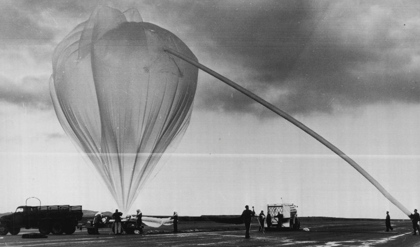
In the 1950's the site would be used again by the US Air Force, being denominated according several sources as "Vernalis Geophysics Annex" and operated by the Air Force Cambridge Research Laboratory. The first use was related to a country wide project started by the Air Force called "Moby Dick" and intended to study the high altitude wind patterns. For this project, Vernalis -among other bases- was choosed to launch stratospheric balloons wich would be tracked by a network of radio receiving stations while traveled throught the US.
Many of the balloons launched there, traveled as far as Mexico, Canada and even Europe.
After the program was completed several other balloons mission took place there during the decade including some flight test of balloon surveillance equipment and a series of launches to test launch techniques and systems as part of a project aimed to detonate a nuclear device in the stratosphere using a balloon as carrier. That mission known as "Yucca" shot took place in 1958 at the Eniwetok Proving Grounds, in the Pacific Ocean.
Some other balloon launches took place there during the remainder of the decade and the first year of the following, but that would be the last ones.
The site remained abandoned until the 70's decades when the runway was used on a more or less regular basis on weekends as drag strip, eventually leading to a formal business and a real track established. Finally by the 80's decade this activity also ceased and from that moment on the terrain occupied by the former base has been used for various purposes including scrap metal, scrap wood processing, and fertilizer manufacturing businesses.
Nowadays, the only remains of the older station is the flag pole and some older buildings.
Much of this history was obtained in Abandoned & Little-Known Airfields an excelent website maintained by Paul Freeman
Table of balloons launched from Vernalis
| Date | Hour | Flight Duration | Experiment | Payload landing place or cause of the failure |
|---|---|---|---|---|
| 1/8/1953 | 15:05 | 80 h 55 m | MOBY DICK | Last known position of the balloon in flight was 33.9º N - 85.8º W |
| 1/10/1953 | 13:01 | 16 h | MOBY DICK | In Embry, Mississipi |
| 1/16/1953 | 13:15 | 52 h 20 m | MOBY DICK | Payload lost. Last known position of the balloon in flight was 43.4º N - 78.9º W |
| 1/18/1953 | 13:26 | 15 h 35 m | MOBY DICK | Payload lost. Last known position of the balloon in flight was 32.2º N - 117.3º W |
| 1/30/1953 | 15:02 | 20 h 30 m | MOBY DICK | In Concepcion del Oro, Zacatecas, Mexico |
| 2/1/1953 | 15:55 | 51 h 6 m | MOBY DICK | Payload lost. Last known position of the balloon in flight was 33.0º N - 79.0º W |
| 2/3/1953 | 16:00 | 10 h 30 m | MOBY DICK | In Morrison, Colorado |
| 2/5/1953 | 18:06 | 11 h 25 m | MOBY DICK | Payload lost. Last known position of the balloon in flight was 32.2º N - 112.9º W |
| 2/6/1953 | 15:06 | 20 h 55 m | MOBY DICK | In Juan Aldama, Zacatecas, Mexico |
| 2/7/1953 | 16:00 | 13 h 25 m | MOBY DICK | Payload lost. Last known position of the balloon in flight was 34.2º N - 118.7º W |
| 2/8/1953 | 15:51 | 30 h 15 m | MOBY DICK | 12 miles S of Saint Francis, Kansas, US |
| 2/10/1953 | 15:50 | 30 h 35 m | MOBY DICK | Payload lost. Last known position of the balloon in flight was 31.0º N - 109.2º W |
| 2/12/1953 | 20:16 | 32 h 40 m | MOBY DICK | Payload lost. Last known position of the balloon in flight was 33.8º N - 118.7º W |
| 2/13/1953 | 16:45 | 55 h 50 m | MOBY DICK | Payload lost. Last known position of the balloon in flight was 31.9º N - 114.5º W |
| 2/16/1953 | 18:41 | 18 h 50 m | MOBY DICK | Payload lost. Last known position of the balloon in flight was 35.6º N - 111.4º W |
| 2/17/1953 | 15:57 | 35 h 35 m | MOBY DICK | In Sheridan Lake, Colorado |
| 2/19/1953 | 16:35 | 15,4 h | MOBY DICK | 14 miles SW of Casa Grande, Arizona, US |
| 2/20/1953 | 16:08 | 29,4 h | MOBY DICK | 10 miles S of Kirkland, Arizona, US |
| 2/21/1953 | 16:48 | 57,2 h | MOBY DICK | --- No Data --- |
| 2/22/1953 | 17:22 | 9,6 h | MOBY DICK | 11 miles E of Springfield, Colorado, US |
| 2/25/1953 | 17:37 | 9,4 h | MOBY DICK | At coordinates 37.3º N - 122.8º O |
| 2/26/1953 | 15:53 | 37,6 h | MOBY DICK | --- No Data --- |
| 3/4/1953 | 16:34 | 22 h 25 m | MOBY DICK | In Thompsonville, Illinois |
| 3/5/1953 | 19:20 | 36 h 10 m | MOBY DICK | Payload lost. Last known position of the balloon in flight was 35.6º N - 109.5º W |
| 3/6/1953 | 17:59 | 56 h 30 m | MOBY DICK | In Hoehne, Colorado |
| 3/7/1953 | 17:50 | 44 h 40 m | MOBY DICK | Payload lost. Last known position of the balloon in flight was 37.9º N - 89.9º W |
| 3/8/1953 | 17:12 | 7 h 20 m | MOBY DICK | 3 miles N and 5 miles E of Auburn, Nebraska |
| 3/9/1953 | 17:05 | 57 h 25 m | MOBY DICK | In Kitty Hawk, N Caroline |
| 3/13/1953 | 14:24 | 21 h 35 m | MOBY DICK | 18 miles N of Ogallala, Nebraska, US |
| 3/13/1953 | 00:21 | 13 h 10 m | MOBY DICK | 30 miles northeast of No. Platte, Nebraska |
| 3/14/1953 | 20:40 | 21 h 20 m | MOBY DICK | Payload lost. Last known position of the balloon in flight was 38.5º N - 111.7º W |
| 3/16/1953 | 13:30 | 12 h | MOBY DICK | Payload lost. Last known position of the balloon in flight was 38.6º N - 116.9º W |
| 3/24/1953 | 16:48 | 38 h 40 m | MOBY DICK | 3 miles southeast of Birchtree, Missouri |
| 3/30/1953 | 16:56 | 33 h 35 m | MOBY DICK | 6 miles W of Nederland, Texas |
| 4/1/1953 | 17:10 | 8 h 20 m | MOBY DICK | Payload lost. Last known position of the balloon in flight was 37.8º N - 119.8º W |
| 4/9/1953 | 16:35 | 14 h 25 m | MOBY DICK | In Lodge Pole, Nebraska |
| 4/11/1953 | 17:17 | 13 h 10 m | MOBY DICK | In Hamblin, Brown County, Indiana |
| 4/14/1953 | 00:37 | 8 h 25 m | MOBY DICK | Payload lost. Last known position of the balloon in flight was 37.8º N - 114.8º W |
| 4/15/1953 | 17:13 | 32 h 20 m | MOBY DICK | Payload lost. Last known position of the balloon in flight was 30.0º N - 85.5º W |
| 4/16/1953 | 16:31 | 6 h | MOBY DICK | 6 miles E of Mt. Vernon, Ohio |
| 4/17/1953 | 19:15 | 7 h 50 m | MOBY DICK | Payload lost. Last known position of the balloon in flight was 36.8º N - 117.8º W |
| 4/18/1953 | 16:39 | 26 h 55 m | MOBY DICK | In Proctor, Nevada |
| 4/21/1953 | 16:44 | 82 h 20 m | MOBY DICK | 4 miles southwest of Indian Springs Air Force Base, Nevada |
| 4/23/1953 | 16:28 | 56 h 30 m | MOBY DICK | In the Gulf of Mexico, near Port Aronsas, Texas, US |
| 4/26/1953 | 18:53 | 40 h 35 m | MOBY DICK | Payload lost. Last known position of the balloon in flight was 34.1º N - 115.3º W |
| 4/28/1953 | 16:38 | 9 h | MOBY DICK | In Sabinas, Coahuila State, Mexico |
| 4/29/1953 | 17:08 | 29 h 25 m | MOBY DICK | Payload lost. Last known position of the balloon in flight was 42.3º N - 120.2º W |
| 5/1/1953 | 16:44 | 5 h 20 m | MOBY DICK | Payload lost. Last known position of the balloon in flight was 36.2º N - 116.5º W |
| 5/2/1953 | 16:24 | 13 h 35 m | MOBY DICK | 1 mile W of Ariuaca, Arizona, US |
| 5/3/1953 | 16:50 | 51 h 40 m | MOBY DICK | In Salina Spring, Arizona |
| 5/4/1953 | 16:37 | 32 h 55 m | MOBY DICK | Payload lost. Last known position of the balloon in flight was 33.3º N - 94.5º W |
| 5/7/1953 | 12:58 | 19 h | MOBY DICK | Payload lost. Last known position of the balloon in flight was 38.7º N - 117.2º W |
| 5/9/1953 | 16:28 | 13 h 30 m | MOBY DICK | 5 miles NE of Potter, Nebraska |
| 5/11/1953 | 18:05 | 18 h 55 m | MOBY DICK | 7 miles E of San Carlos, Arizona |
| 5/12/1953 | 16:08 | 19 h 55 m | MOBY DICK | 17 miles W of Needles, California, US |
| 5/13/1953 | 17:17 | 57 h 40 m | MOBY DICK | Payload lost. Last known position of the balloon in flight was 44.7º N - 84.2º W |
| 5/14/1953 | 21:44 | 11 h 18 m | MOBY DICK | 4 miles E of Heron Lake, Minnesota |
| 5/15/1953 | 19:26 | 7 h 5 m | MOBY DICK | In Lancaster, California |
| 5/17/1953 | 16:55 | 9 h 5 m | MOBY DICK | In Macedonia, Ohio |
| 5/18/1953 | 17:12 | 26 h 50 m | MOBY DICK | In Garden County, Nebraska |
| 5/19/1953 | 09:02 | 10 h | MOBY DICK | Payload lost. Last known position of the balloon in flight was 32.6º N - 111.0º W |
| 5/25/1953 | 13:30 | 12 h 30 m | MOBY DICK | Payload lost. Last known position of the balloon in flight was 47.2º N - 116.5º W |
| 5/26/1953 | 16:10 | 81 h 20 m | MOBY DICK | In Ganado, Arizona |
| 6/3/1953 | 16:53 | 9 h 36 m | MOBY DICK | 4 miles N of Maxbass, N Dakota |
| 6/4/1953 | 10:31 | 18 h 30 m | MOBY DICK | Payload lost. Last known position of the balloon in flight was 33.5º N - 109.2º W |
| 6/5/1953 | 17:14 | 12 h 20 m | MOBY DICK | In Gloucester County, Virginia |
| 6/17/1953 | 18:00 | 10 h 30 m | MOBY DICK | 15 miles E of Guadalupe Island, Mexico |
| 6/22/1953 | 16:58 | 6 h | MOBY DICK | In Meeker, Colorado |
| 6/25/1953 | 16:45 | 7 h 50 m | MOBY DICK | Payload lost. Last known position of the balloon in flight was 39.0º N - 120.3º W |
| 6/26/1953 | 16:43 | 7 h 20 m | MOBY DICK | In Orem Juab county, Utah |
| 6/30/1953 | 16:50 | 7 h 10 m | MOBY DICK | 300 miles NE of Winnipeg. Canada |
| 7/8/1953 | 17:12 | 11 h 50 m | MOBY DICK | NE of Scotts Bluff, Nebraska |
| 7/12/1953 | 17:26 | 9 h 35 m | MOBY DICK | In Plumas County, California |
| 7/19/1953 | 17:28 | 20 h 30 m | MOBY DICK | In Holden, Utah |
| 8/1/1953 | 18:14 | 7 h 18 m | MOBY DICK | In Cando, Saskatchewan Province, Canada |
| 8/13/1953 | 17:50 | 12 h 10 m | MOBY DICK | Payload lost. Last known position of the balloon in flight was 38.8º N - 121.4º W |
| 8/18/1953 | 15:59 | 12 h 30 m | MOBY DICK | In Randolph, Utah |
| 8/26/1953 | 17:00 | 6 h 30 m | MOBY DICK | In Cody, Wyoming |
| 8/31/1953 | 16:44 | 14 h 50 m | MOBY DICK | 70 miles S of St.George, Utah |
| 9/16/1953 | 16:54 | 29 h 35 m | MOBY DICK | Payload lost. Last known position of the balloon in flight was 37.8º N - 123.7º W |
| 9/18/1953 | 18:16 | 26 h 10 m | MOBY DICK | In Lexington, N Carolina |
| 9/23/1953 | 17:20 | 32 h 40 m | MOBY DICK | 8 miles NW of McCamey, Texas |
| 9/25/1953 | 17:21 | 54 h 10 m | MOBY DICK | In the Fenwick Island, Delaware |
| 9/27/1953 | 17:01 | 7 h 30 m | MOBY DICK | Payload lost. Last known position of the balloon in flight was 37.6º N - 118.2º W |
| 10/3/1953 | 17:27 | 25 h 36 m | MOBY DICK | Payload lost. Last known position of the balloon in flight was 36.5º N - 123.2º W |
| 10/4/1953 | 16:39 | 9 h 55 m | MOBY DICK | In McGill, Nevada |
| 10/8/1953 | 17:40 | 8 h 20 m | MOBY DICK | 11 miles S of Georgetown, Colorado, US |
| 10/13/1953 | 16:37 | 31 h 25 m | MOBY DICK | In Shelton, Washington |
| 10/29/1953 | 17:13 | 80 h 35 m | MOBY DICK | Payload lost. Last known position of the balloon in flight was 43.8º N - 70.6º W |
| 10/30/1953 | 17:47 | 15 h 15 m | MOBY DICK | In Ciudad Obregon, Sonora State, Mexico |
| 11/6/1953 | 17:16 | 6 h 40 m | MOBY DICK | Payload lost. Last known position of the balloon in flight was 35.3º N - 118.4º W |
| 11/15/1953 | 15:17 | 15 h 42 m | MOBY DICK | In Mazapil, Zacatecas State, Mexico |
| 12/2/1953 | 17:50 | 16 h 10 m | MOBY DICK | 19 miles NW of Albany, Texas, US |
| 12/7/1953 | 18:36 | 45 h 55 m | MOBY DICK | Payload lost. Last known position of the balloon in flight was 42.9º N - 70.8º W |
| 1/9/1954 | 17:31 | 16 h | MOBY DICK | In San Angelo, Texas |
| 2/15/1954 | 20:33 | 23 h 30 m | MOBY DICK | Payload lost. Last known position of the balloon in flight was 35.4º N - 97.0º W |
| 2/18/1954 | 17:14 | 83 h 20 m | MOBY DICK | Payload lost. Last known position of the balloon in flight was 37.7º N - 96.3º W |
| 4/2/1954 | 20:14 | 32 h 50 m | MOBY DICK | Payload lost. Last known position of the balloon in flight was 33.6º N - 81.5º W |
| 4/3/1954 | 16:30 | 40 h | MOBY DICK | Payload lost. Last known position of the balloon in flight was 32.3º N - 79.9º W |
| 4/21/1954 | 17:40 | 57 h 20 m | MOBY DICK | In Pinco Mesa, Tucunmari, New Mexico, US |
| 5/1/1954 | 16:40 | 55 h 50 m | MOBY DICK | Payload lost. Last known position of the balloon in flight was 40.2º N - 120.2º W |
| 5/2/1954 | 15:40 | 10 h 50 m | MOBY DICK | Payload lost. Last known position of the balloon in flight was 31.4º N - 113.2º W |
| 5/5/1954 | 16:19 | 33 h 10 m | MOBY DICK | Payload lost. Last known position of the balloon in flight was 32.9º N - 81.8º W |
| 5/12/1954 | 16:04 | 71 h 55 m | MOBY DICK | In Floyd, Virginia |
| 5/13/1954 | 16:00 | 7 h | MOBY DICK | Payload lost. Last known position of the balloon in flight was 37.5º N - 116.1º W |
| 6/2/1954 | 19:47 | 25 h 40 m | MOBY DICK | Payload lost. Last known position of the balloon in flight was 37.5º N - 96.5º W |
| 6/3/1954 | 15:38 | 59 h 25 m | MOBY DICK | Payload lost. Last known position of the balloon in flight was 36.2º N - 74.6º W |
| 6/15/1954 | 15:47 | 11 h 40 m | MOBY DICK | 50 mils S of Flagstaff, Arizona |
| 6/24/1954 | 15:35 | 8 h 25 m | MOBY DICK | Payload lost. Last known position of the balloon in flight was 37.5º N - 119.6º W |
| 10/8/1954 | --- | WS-124A (FLYING CLOUD) TEST FLIGHT | --- No Data --- | |
| 10/9/1954 | --- | WS-124A (FLYING CLOUD) TEST FLIGHT | --- No Data --- | |
| 10/11/1954 | --- | WS-124A (FLYING CLOUD) TEST FLIGHT | --- No Data --- | |
| 11/30/1954 | --- | WS-124A (FLYING CLOUD) TEST FLIGHT | --- No Data --- | |
| 12/13/1954 | --- | WS-124A (FLYING CLOUD) TEST FLIGHT | --- No Data --- | |
| 1/20/1955 | --- | BARBERSHOP | --- No Data --- | |
| 1/20/1955 | --- | BARBERSHOP | --- No Data --- | |
| 1/20/1955 | --- | BARBERSHOP | --- No Data --- | |
| 1/20/1955 | --- | BARBERSHOP | --- No Data --- | |
| 1/20/1955 | --- | BARBERSHOP | --- No Data --- | |
| 1/20/1955 | --- | BARBERSHOP | --- No Data --- | |
| 1/20/1955 | --- | BARBERSHOP | --- No Data --- | |
| 1/20/1955 | --- | BARBERSHOP | --- No Data --- | |
| 1/20/1955 | --- | BARBERSHOP | --- No Data --- | |
| 1/20/1955 | --- | BARBERSHOP | --- No Data --- | |
| 3/4/1955 | --- | BARBERSHOP | --- No Data --- | |
| 3/4/1955 | --- | BARBERSHOP | --- No Data --- | |
| 3/4/1955 | --- | BARBERSHOP | --- No Data --- | |
| 3/4/1955 | --- | BARBERSHOP | --- No Data --- | |
| 3/4/1955 | --- | BARBERSHOP | --- No Data --- | |
| 3/4/1955 | --- | BARBERSHOP | --- No Data --- | |
| 3/4/1955 | --- | BARBERSHOP | --- No Data --- | |
| 3/4/1955 | --- | BARBERSHOP | --- No Data --- | |
| 3/4/1955 | --- | BARBERSHOP | --- No Data --- | |
| 3/4/1955 | --- | BARBERSHOP | --- No Data --- | |
| 5/13/1955 | --- | PAYLOAD UNKNOWN | --- No Data --- | |
| 5/13/1955 | --- | BARBERSHOP | --- No Data --- | |
| 5/13/1955 | --- | BARBERSHOP | --- No Data --- | |
| 5/13/1955 | --- | BARBERSHOP | --- No Data --- | |
| 5/13/1955 | --- | BARBERSHOP | --- No Data --- | |
| 5/13/1955 | --- | BARBERSHOP | --- No Data --- | |
| 5/13/1955 | --- | BARBERSHOP | --- No Data --- | |
| 5/13/1955 | --- | BARBERSHOP | --- No Data --- | |
| 5/13/1955 | --- | BARBERSHOP | --- No Data --- | |
| 5/13/1955 | --- | BARBERSHOP | --- No Data --- | |
| 5/13/1955 | --- | BARBERSHOP | --- No Data --- | |
| 1/8/1956 | --- | PAYLOAD UNKNOWN | --- No Data --- | |
| 1/28/1956 | --- | METEOROLOGICAL STUDIES | --- No Data --- | |
| 8/2/1956 | --- | BARBERSHOP | --- No Data --- | |
| 8/2/1956 | --- | BARBERSHOP | --- No Data --- | |
| 8/2/1956 | --- | BARBERSHOP | --- No Data --- | |
| 8/2/1956 | --- | BARBERSHOP | --- No Data --- | |
| 8/2/1956 | --- | BARBERSHOP | --- No Data --- | |
| 8/2/1956 | --- | BARBERSHOP | --- No Data --- | |
| 8/2/1956 | --- | BARBERSHOP | --- No Data --- | |
| 8/2/1956 | --- | BARBERSHOP | --- No Data --- | |
| 8/2/1956 | --- | BARBERSHOP | --- No Data --- | |
| 8/2/1956 | --- | BARBERSHOP | --- No Data --- | |
| 8/2/1956 | --- | BARBERSHOP | --- No Data --- | |
| 8/2/1956 | --- | BARBERSHOP | --- No Data --- | |
| 8/2/1956 | --- | BARBERSHOP | --- No Data --- | |
| 8/2/1956 | --- | BARBERSHOP | --- No Data --- | |
| 8/2/1956 | --- | BARBERSHOP | --- No Data --- | |
| 8/2/1956 | --- | BARBERSHOP | --- No Data --- | |
| 8/2/1956 | --- | BARBERSHOP | --- No Data --- | |
| 8/2/1956 | --- | BARBERSHOP | --- No Data --- | |
| 8/2/1956 | --- | BARBERSHOP | --- No Data --- | |
| 8/2/1956 | --- | BARBERSHOP | --- No Data --- | |
| 8/2/1956 | --- | BARBERSHOP | --- No Data --- | |
| 8/2/1956 | --- | BARBERSHOP | --- No Data --- | |
| 8/2/1956 | --- | BARBERSHOP | --- No Data --- | |
| 8/2/1956 | --- | BARBERSHOP | --- No Data --- | |
| 8/2/1956 | --- | BARBERSHOP | --- No Data --- | |
| 8/2/1956 | --- | BARBERSHOP | --- No Data --- | |
| 8/2/1956 | --- | BARBERSHOP | --- No Data --- | |
| 8/2/1956 | --- | BARBERSHOP | --- No Data --- | |
| 8/2/1956 | --- | BARBERSHOP | --- No Data --- | |
| 10/21/1956 | --- | PAYLOAD UNKNOWN | Near Modesto, California, US | |
| 10/21/1957 | --- | PAYLOAD UNKNOWN | --- No Data --- | |
| 4/9/1959 | 7:14 local | --- | PAYLOAD UNKNOWN | --- No Data --- |
| 2/29/1960 | 15:00 local | 1 h | PAYLOAD UNKNOWN | Balloon burst at 35.000 ft over Empire, California, US |
| 4/25/1960 | 5 d | PAYLOAD UNKNOWN | Cap-aux-Meules, Quebec, Canada | |
| 8/29/1960 | 6:11 local | --- | TECHNOLOGICAL FLIGHT | Balloon burst at 40.000 ft over Stockton, California, US |
| 10/30/1960 | 1 d 12 h | TECHNOLOGICAL FLIGHT | 20 miles E of Oklahoma City, US | |
| 11/1/1960 | --- | GRATING SPECTROGRAPH | --- No Data --- | |
| 2/20/1961 | 8 h | PAYLOAD UNKNOWN | --- No Data --- | |
| 2/24/1961 | 27 h | PAYLOAD UNKNOWN | --- No Data --- | |
| 4/17/1961 | 13:53 utc | 9 d | SUPERPRESSURE BALOON TEST | In the Pacific Ocean, 400 miles off the coast of the State of Washington, US |
| 6/19/1961 | 6 h | PAYLOAD UNKNOWN | --- No Data --- | |
| 6/22/1961 | 5 d | PAYLOAD UNKNOWN | Aleutian Islands, Alaska, US |
If you consider this website interesting or useful, you can help me to keep it up and running with a small donation to cover the operational costs. Just the equivalent of the price of a cup of coffee helps a lot.
