Purpose of the flight and payload description
SUNRISE is a balloon-borne solar observatory dedicated to the investigation of the key processes governing the physics of the magnetic field and the convective plasma flows in the lower solar atmosphere. The instrument is the largest balloon-borne solar observatory ever flown. It was developed by an international consortium led by the Max Planck Institute for Solar System Research (MPS) and a huge collaboration of institutions from all over the world that included the Leibniz Institute from Germany, the Johns Hopkins University from US, the National Observatory of Japan, the Instituto de Astrofísica de Andalucía, Instituto de Astrofísica de Canarias and Instituto Nacional de Técnica Aeroespacial, from Spain and a partnergroup formed by Max Planck and UTN-FRM CONICET from Argentina.
SUNRISE is designed for operation in the stratosphere in order to avoid the image degradation due to turbulence in the lower terrestrial atmosphere and to gain access to the UV range down to 200 nm. By launching it from above the polar circle at solstice conditions, enables an uninterrupted view at the Sun for extended periods of several days.
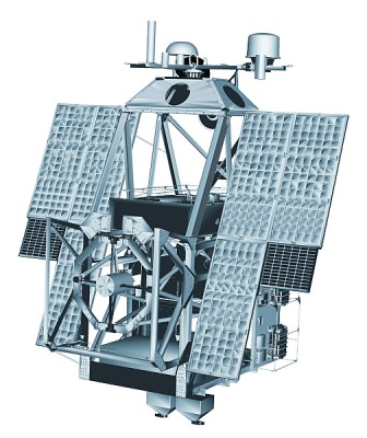
At left, we can see a detailed scheme of the instrument in flight configuration (click to obtain a more detailed view).
The gondola developed at APL provides all the infrastructure necessary for the telescope and its post-focus instrumentation. Momentum wheels compensate for the pendulum motions of the gondola, communication devices allow for real-time commanding and data transmission during the flight. Attached to the balloon via a parachute it guarantees stable observing conditions and a safe landing of the scientific payload. The telescope with his 1 meter main mirror delivers the high-resolution solar images. Then the image stabilization and light distribution unit (ISLiD) corrects for residual image motion and distributes the light to the three science instruments:
SUSI (Sunrise Ultra-violet Spectropolarimeter and Imager) developed by MPS is a grating based spectropolarimeter aimed to explore the rich near-UV range between 300 nm and 410 nm which is to a large extent poorly accessible from the ground. A multitude of spectral lines combined observed at highest spatial and spectral resolution combined with the stability of the Sunrise III observatory will offer unique opportunities to study the coupling between the various layers of the solar atmosphere.
TuMag (Tunable Magnetograph) developed by a Spanish Consortium is an imaging spectropolarimeter delivering 2D maps of two different layers in the solar atmosphere, the deep photosphere and the chromosphere, at high temporal cadence (2 maps per minute).
SCIP (Sunrise Chromospheric Infrared spectroPolarimeter) developed at NAOJ will allow to measure the chromosphere using the well-known Ca infrared line, and combine the information with lines formed in the deep to upper photosphere.
The onboard computer (known as Instrument Control System, or ICS) controls and supervises all its functions, as well the storage of scientific and housekeeping data on the on-board data storage system. In addition, the communication system allows for real-time commanding of the observatory from the ground station and sends down thumbnail images to evaluate its performance during the flight.
Video footage of the Sunrise III flight as seen by IRIS-2 video system
Details of the balloon flight

Balloon launched on: 7/10/2024 at 4:22 UTC
Launch site: European Space Range, Kiruna, Sweden
Balloon launched by: Columbia Scientific Balloon Facility (CSBF)
Balloon manufacturer/size/composition: Zero Pressure Balloon Aerostar - SF 34.43H - (34.430.000 cuft)
Flight identification number: 740N
End of flight (L for landing time, W for last contact, otherwise termination time): 7/16/2024 at 19:00 UTC (L)
Balloon flight duration (F: time at float only, otherwise total flight time in d:days / h:hours or m:minutes - ): 6 d 15 h
Landing site: E of Fort Good Hope,Sahtu Region,Northwest Territories, Canada
The balloon was launched from ESRANGE at 4:22 UTC on July 10, 2024. After a nominal ascent phase it reached float altitude of 125.000 ft and started the westward crossing of the Atlantic Ocean towards Canada. The flight was terminated at 18:20 utc on July 16, 2024. Landing occured in a spot located east of Fort Good Hope, a charter community in the Sahtu Region of the Northwest Territories, Canada. Total flight time was 6 days and 15 hours.
External references
- SUNRISE III website at Max-Planck-Gesellschaft
- At the last second: Sunrise III launches successfully Max-Planck-Gesellschaft website
- First Solar Images from Sunrise III Max Planck Institute for Solar System Research, Göttingen
- International solar observatory lands successfully in Sahtu region NNSL Media
- NASA balloons study atmosphere and cosmos Physics Today 77 (10), 22-23 (2024)
- NASA SUNRISE-III balloon launched SSC website
- Sunrise III: Data Storage Recovered Press Release by Max-Planck-Gesellschaft
16592If you consider this website interesting or useful, you can help me to keep it up and running with a small donation to cover the operational costs. Just the equivalent of the price of a cup of coffee helps a lot.


