 GOES Data Collection System (GDCS)
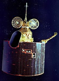
The GOES Data Collection System (DCS) is a information relay system installed onboard the GOES (Geostationary Operational Environmental Satellite). GOES consists of two meteorological satellites in geostationary orbit over the equator that are operated by the National Oceanic and Atmospheric Administration (NOAA).
The DCS system uses the GOES spacecraft for the relay of data from remotely located platforms sites at or near the Earth's surface. These can be fixed ones or attached to mobile devices like balloons or buoys.
The environmental data observed by the sensors on the platform is transmited in form of an electronic signal, at predefined wavelengths and times. The transponder on board the satellite detects this signal, then rebroadcasts it so that it can be picked up by the ground equipment at the Wallops Command and Data Acquisition (CDA) station, in Wallops Island, Virginia. During this rebroadcast any ground receiving equipment with the correct configuration can also receive this signal.
This system was often used to retransmit the data obtained by balloon-borne instruments flying in the stratosphere during long durations missions back in the 80's and 90's. One example was the EOSCOR (Extended Observation of Solar and Cosmic Radiation) mission launched from Alice Springs, Australia on January 19, 1983. It stayed afloat for 22 days until it descended in the Indian Ocean on February 11. It circumnavigated the earth along the 20º southern parallel. Data were disseminated via GOES DCS as well as being stored on board.
External Links
GOES Data Collection System page - at NOAA website
About StratoCat
Some Statistics
+ 20 articles from different contributors
+ 15914 balloon launch records already published
+ 16008 balloon launch records in the full database
StratoCat is a non-profit, educational and informative website created, developed and programmed by Luis E. Pacheco. It is based on an idea first conceived by the author in 2001 and is online since September 17th, 2005.
This website is an independent initiative, and thus is not endorsed, supported or have any relationship with any governmental or private agency or company in the balloon field.
Page generated on 9-Mar-2026 - 09:00:31am  © StratoCat 2005~2026 - All Rights Reserved.