Purpose of the flight and payload description
Project Loon was an initiative to establish a network of high altitude unmanned balloons to provide Internet connectivity in underserved parts of the world or during disaster recovery efforts. The project started in experimental form in 2011 and became public in 2013 as part of Google's research and development of new technologies carried out through X Development LLC. The Loon Project used superpressure balloon fleets capable of long-duration flights to create a network that would provide connectivity to people in a defined area in the same way that a group of cell phone towers on the ground form a terrestrial network. The project was terminated in 2021 due to its financial unsustainability.
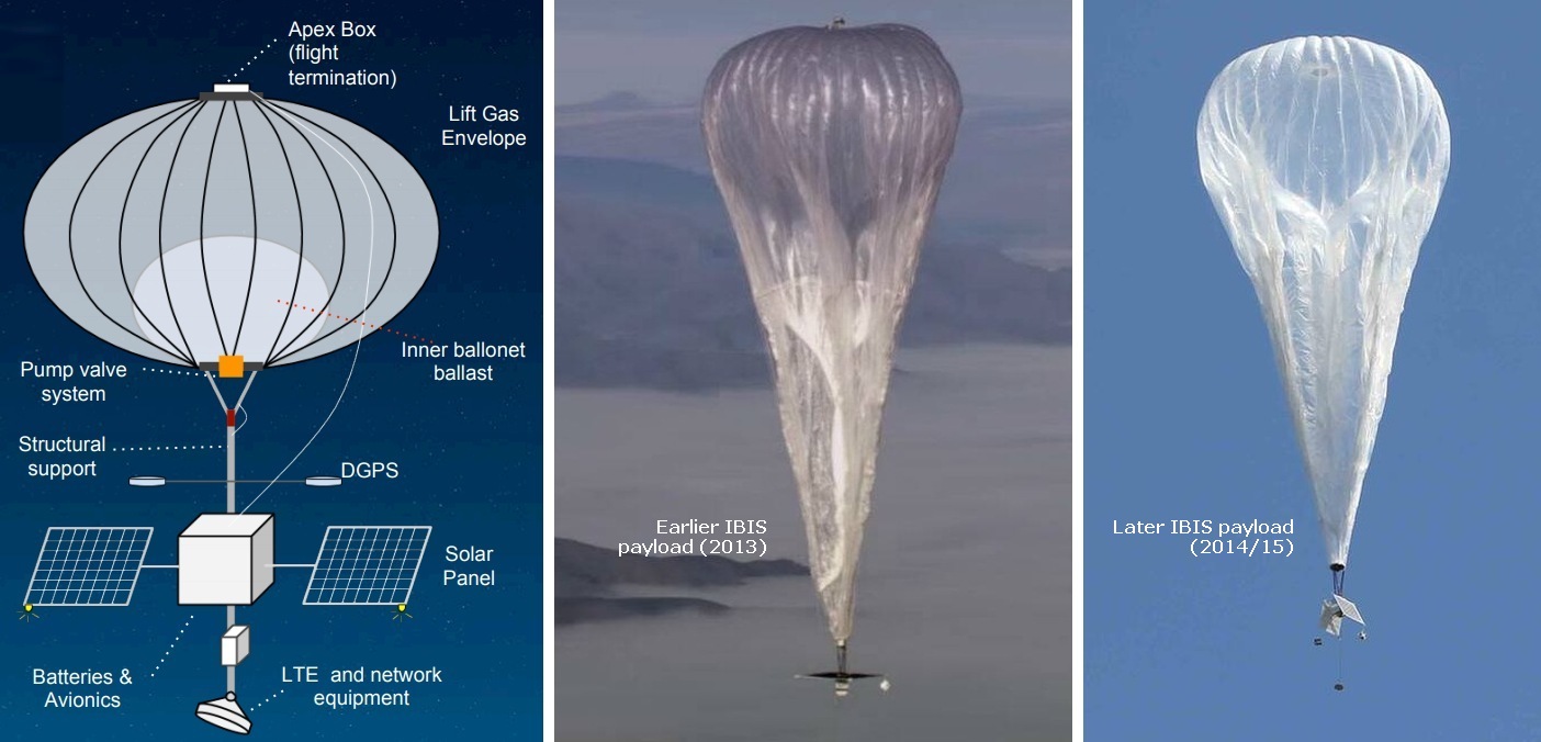
At left we can see a basic scheme of the system (not to scale). The elements that made up the Loon system are described below
Superpressure balloon
The vehicle used in the I series of flights (code named IBIS that flew between 2012 and 2016) was a pumpkin-shaped superpressure balloon manufactured by Raven Aerostar using polyethylene with dimensions at float of 7.4 meters high and a radius of 8.9 meters. The combined mass of payload and envelope that this model was capable of lifting was between 49 and 155 kilograms. It was filled at launch with 12 to 24 kilograms of helium. The floating altitude of the balloons was in the range of 18 to 23 km (60,000 to 75,000 feet) well above commercial aircraft and weather events. The heart of the Loon system was the Altitude Control System (ACS), which allowed the balloon to change altitude pumping air into a separate gas bag inside the main balloon (called a ballonet) to cause the balloon to descend, and vent air from the ballonet to cause the balloon to ascend again. Balloons would then be "steered" to a target by catching winds at different altitudes. The balloon also had a valve in the upper part that was used to ventilate the helium at the end of the flight, as well as envelope cutters, to prevent it from rising again if caught by the wind once landed.
Payload
The flight system or payload located below the balloon varied from one series of flights to other and evolved a lot over time. It basically contained the flight computer, environmental sensors, a transponder (A/C mode and ADS-B Out capability on certain flights), a GPS receiver, an Iridium satellite tranceptor and a parachute. Location parameters like latitude, longitude, and geometric altitude were all collected using a NovAtel OEM7 receiver, which processed signals collected by the standard dual GPS paddle antennas located on either side of the avionics bus. The avionics bus was located between 1.5 and 3 meters below the base of the balloon envelope in an insulated styrofoam structure. Regarding the internet payload each balloon carried two sets of antennas: one to send signals to the ground station or subscribers, and another to communicate with other balloons. This balloon-to-balloon network is what carries the internet signal from a subscriber's house to a fixed line network, such as fibre backhaul. The communications systems on these earlier balloons used the 2.4 GHz and 5 GHz radio spectrum, which are generally unlicensed around the world.
Initial models used a single solar panel mounted flat on top, pointing up at the sun. However, after some testing it was changed to a pair of panels, facing each other diagonally. These panels powered the entire system during the day, while charged lithium batteries that powered the systems at night. The entire structure was firmly attached to the balloon through several rigid tethers to ensure that both elements remained together during the descent. Although the balloons flew well above commercial aviation, they had several safety measures to rule out any possibility of collision: the entire structure was covered by radar reflective material, in each corner of the solar panels there was an omnidirectional white strobe light with a range of 5 nautical miles that flashed once per second, and a transponder constantly transmitted the position and altitude of the balloon to air traffic control and other nearby aircraft.
The positioning of the balloon fleet was controlled in real time using high-frequency telemetry and satellite links.
Details of the balloon flight
Balloon launched on: 6/11/2013 at 21:31 utc
Launch site: Lake Tekapo Aerodrome, New Zealand
Balloon launched by: Loon LLC
Balloon manufacturer/size/composition: Pumpkin-shaped superpressure balloon 7.4 x 8.9 meters - Codename: IBIS
Flight identification number: I-068
End of flight (L for landing time, W for last contact, otherwise termination time): 6/11/2013 at (L) 7:24 utc
Balloon flight duration (F: time at float only, otherwise total flight time in d:days / h:hours or m:minutes - ): 1 d 9 h 54 m
Landing site: Ditched in the Pacific Ocean
External references
- Project Loon Website
- Interactive flight path of the balloon extracted from Loon Stratospheric Sensor Data set
If you consider this website interesting or useful, you can help me to keep it up and running with a small donation to cover the operational costs. Just the equivalent of the price of a cup of coffee helps a lot.
