Purpose of the flight and payload description
HASI which stands for Huygens Atmospheric Structure Instrument was a multisensor package designed to measure the physical quantities characterizing Titan's atmosphere onboard the HUYGENS lander. The probe was part of the NASA/ESA/ASI mission CASSINI devoted to study Saturn and his moons that was designed to enter and brake in Titan's atmosphere and parachute a fully instrumented robotic laboratory down to it's surface. The mission, launched in October of 1997, reached Saturn's orbit on July 2004. Orbital entry of Huygens occured on January 15, 2005. The probe studied the clouds, atmosphere, and surface of Titan in its descent.
Between 1995 and 2004, as part of the research program in preparation for the mission, different agencies participating of the program performed a series of balloon-borne missions using different mockups of the probe, and specially built gondolas for testing different sub-systems and sensors. Also several stratospheric drop tests were made to simulate orbital entry into Titan's atmosphere.
The objective of this second flight of a series of three, was to perform a drop test from a balloon over Sicily, Italy. For this purpose scientists from the University of Padova, designed and built a specially engineered probe, similar to the one launched to Titan suitable for a balloon launch and capable of collecting all HASI scientific measurements during the parachute drop in the Earth atmosphere. The main goal was to check HASI operations at instrument level and to verify sensors performance during a realistic functional test in dynamic and environmental conditions similar to those foreseen for the Titan's descent. The test would also provide real data for the exercise descent trajectory reconstruction software and to investigate possible aerodynamic disturbances on pressure and temperature measurements induced by the Huygens probe configuration. Furthermore, data from balloon flight campaigns had a secondary scientific aspect, since they provided a local detail description of physical properties of the Earth's atmosphere: density, pressure and temperature vertical profiles along with magnetic field data.
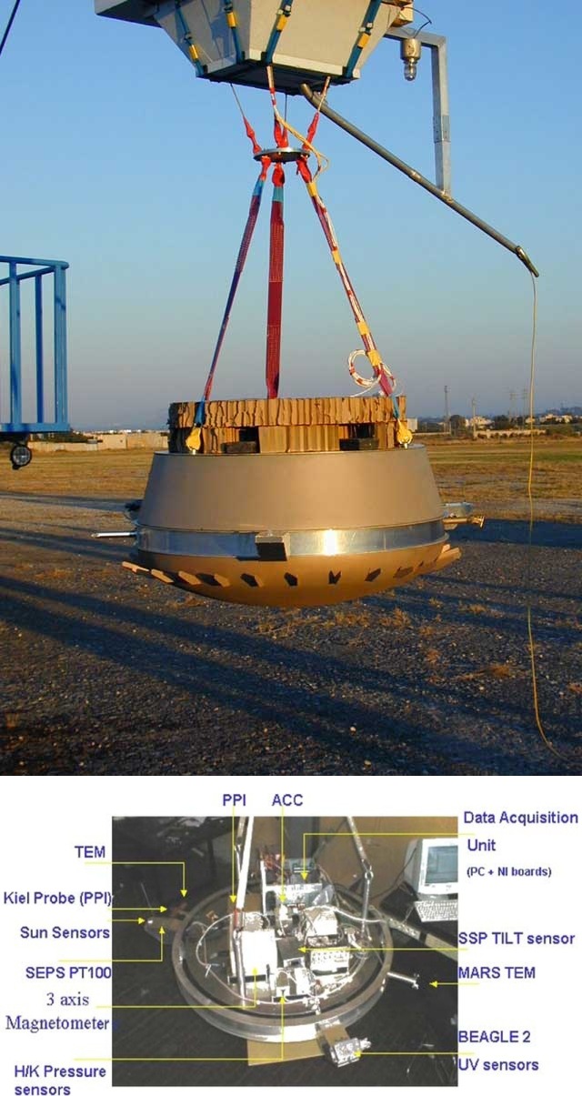
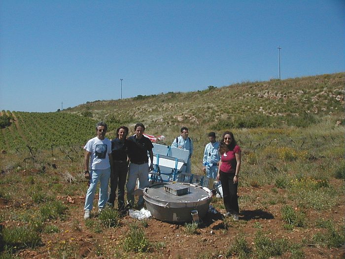
At left above we can see an scheme of the balloon probe. The 1:1 scale mock-up was developed trying to keep both weight and costs at an acceptable level. The main structure was a platform composed of two circular plates of high resistant aluminium alloy, which represented a good trade off between structural properties and mass reduction. Both plates were kept at 50 mm distance gap by nine poles. This main structure was connected with the metallic plate on top of the probe by three poles, that ensured thermal and electric junction among all parts of the system. On the bottom of the main platform was located the battery plate, hosting the main power supply, that in the flight configuration was sheltered in a safe position by surrounding polyurethane foam.
On the border of the main platform an external aluminium ring was fixed, where, external instruments and three box-like extensions were attached in a 120º configuration. These extensions were parts of the Separation Subsytem which in the real mission provided mechanical attachment and separation from the Orbiter. The lower part of the probe showed a set of vans, whose function was to induce a rotation rate similar to the one envisioned for the Titan descent.
The overall external dimensions of the mock-up were 1304 mm of diameter and 631 mm of height while the internal allocated volume for the payload was approximately 0.3 cubic meters. Weight of the mock-up was close to 100 kg and in order to have maximum parachute efficiency a ballast of six lead bricks, having a total 66 kg mass, was added before launch.
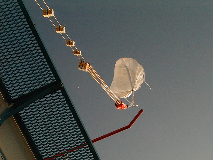
A telemetry box linked the probe to the parachute and balloon. It consisted of an aluminum tubular structure measuring 0.8 m × 0.8 m × 1.0 meters covered with expanded polyestyrene insulating panels and housed the radar transponder, the telecommand antenna, the GPS system and a VAISALA meteorological sonde. Most of the box volume was occupied by the ballast canister containing 100 kg of small lead spheres.
The main part of the scientific payload of the 2002 HASI balloon experiment consisted in threes spare units of HASI: the accelerometer subsystem (ACC), the temperature subsystem (TEM) and the HASI pressure probe instrument subsystem (PPI). The Mars temperature sensors (MTEM), the Beagle 2 UV sensor and the tilt sensor of the Huygens Surface Science Package (SSP) completed the scientific payload; these sensors were added to the HASI units with the aim to test their performances in a flight environment and to provide support data in the analysis of the balloon flight. Housekeeping sensors (temperature, pressure, magnetometer and sun sensor) were included to check the environmental conditions inside the probe mock-up, and to provide redundancy and reference of the measurements done by the HASI and the other sensors.
Details of the balloon flight

Balloon launched on: 5/30/2002 at 6:56 utc
Launch site: Base di Lancio Luigi Broglio, Trapani, Sicily, Italy
Balloon launched by: Agenzia Spaziale Italiana (ASI)
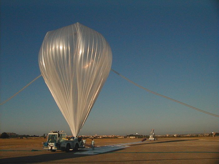
Balloon manufacturer/size/composition: Zero Pressure Balloon Raven - 100.000 m3
End of flight (L for landing time, W for last contact, otherwise termination time): 6/30/2002 at 11:11 utc
Balloon flight duration (F: time at float only, otherwise total flight time in d:days / h:hours or m:minutes - ): 4 h 10 m
Landing site: In southern Sicily, Italy
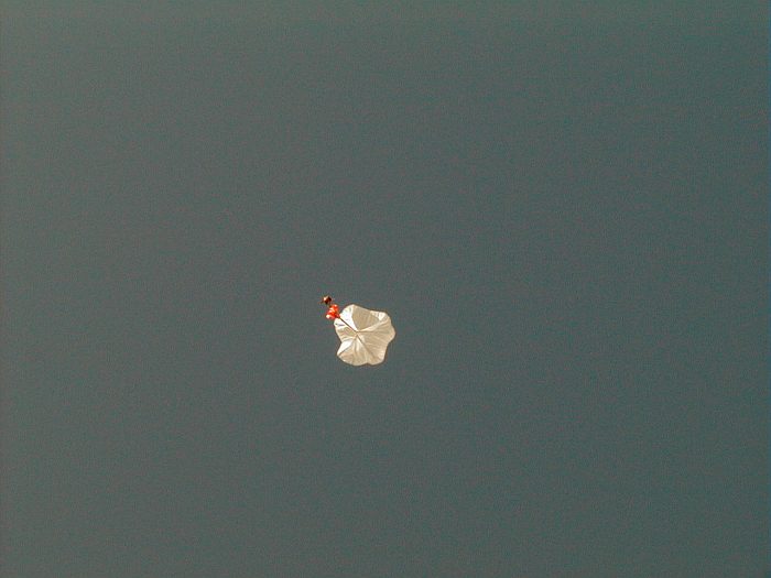
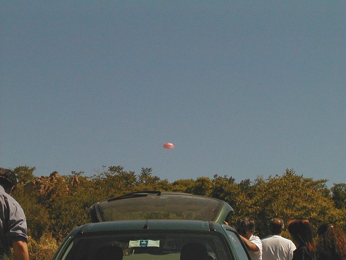
The balloon was launched by dynamic method at 6:56 utc on May 30th, 2002 from the balloon launch base of Trapani in Sicily. After a nominal ascent phase of 120 minutes (marked in red in the map above) the balloon reached an altitude of 32 km and floated there during 90 minutes (green). The separation of the probe occured at 10:10 utc initiating the descent phase of 61 minutes (blue). The payload touched ground in southern Sicily at 11:11 utc.
During the whole flight, the behavior of the instruments was nominal. Ninety-seven percent of the data was recovered by telemetry. The presence of a hill between the telemetry transmitting and receiving antennas caused a loss of the signal during the last 187 seconds of the descent, but 100% of data was recovered from the on-board storage.
External references
- A stratospheric balloon experiment to test the Huygens atmospheric structure instrument (HASI) Planetary and Space Science, Volume 52, Issue 9, p. 867-880
- HASI Stratospheric Balloon Experiments CISAS - Centro Interdipartimentale di Studi e Attività Spaziali (via Archive.Org)
- Huygens/HASI 2002 balloon test campaign: Probe trajectory and atmospheric vertical profiles reconstruction Planetary and Space Science, Volume 52, Issue 9, p. 887-895
- Sicily 2002 balloon campaign: a test of the HASI instrument Advances in Space Research, Volume 33, Issue 10, p. 1806-1811
- The Huygens Atmospheric Structure Instrument (HASI): expected results at Titan and performance verification in terrestrial atmosphere 2nd International Planetary Probe Workshop, April 1, 2005
- Transmediterranean flights, in the edge of two centuries Advances in Space Research Volume 33, Issue 10, 2004, Pages 15941599
Images of the mission
If you consider this website interesting or useful, you can help me to keep it up and running with a small donation to cover the operational costs. Just the equivalent of the price of a cup of coffee helps a lot.
