The Barstow-Daggett airport is located approximately 5 miles east of the community of Daggett and twelve miles east of the City of Barstow, hence the composite name of the air station. The airport is located within the lower Mojave Valley approximately two miles south of the Mojave River and one north of Highway 40, in San Bernardino County, in the south of the California state.
The airport was originally built in 1933 as a Civil Aeronautics Administration (CAA) beacon site, being the oldest of the six airports currently operated by the County.
On May 4, 1942 the Federal Government made an agreement with San Bernardino County to lease 1,099-acres site and operate it as a Modification Center and in November same year, Standard Oil installed a lubricating oil storage and distribution facilities at the site. The main facilities of the airport were built by Douglas Aircraft as a modification plant to support the A-20 (Havoc) plane program, shipping about 1200 of them to the USSR until middle of 1944, when Army Air Forces deactivated the project. Later, the site was used by 444th Air Base Group to support P-38 Units coming in for air to ground rocket training.
Between 1958 and 1960, the U.S. Army donated the airport to the County wich is the current owner. Now the airport cover 1,087 acres and has two paved runways.
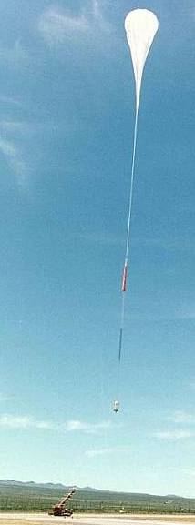
NASA balloons arrive
In the late 80's NASA changed the safety requirements for his balloon program forbidding to make launches from Palestine across the southern US due east.
Initially the program managers thought that doing launches from Ft. Sumner would be their alternative, leting the balloons go into Arkansas and perhaps Tennessee. But NASA again changed safety requirements a year later restricting more the flights into a truncated triangle formed by Dallas, Ft. Sumner, and Oklahoma city with the Oklahoma-Texas border as far east as they could go into that zone. Clearly, the agency wanted to maintain their balloons out of the populated areas of the Oklahoma City - Dallas corridor.
Under these new directives, the balloon program managers started to look a place near the west coast, with the intention of launching balloons to go east and have intermediate telemetry stations at Holbrook, Arizona and Ft. Sumner, terminating the flights in western Oklahoma.
At first, the Barstow-Daggett airport seemed perfect. It was located far from big cities and counted with ample room to launch big balloons and an old military hanger wich was leased to serve as integration building for preparing payloads. The launches were done between the months of Febraury and April.
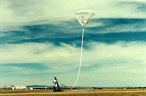
Nevertheless, after the first flights several issues arised. First, as the airport was located in a high desert area the surface winds conditions did not allowed to launch large balloons in a timely fashion.
Althought a heavy crane was available, the only way to have the capability of launching 8,000 lb payloads was to move during the campaigns from Fort Sumner the new large mobile launch vehicle (MLV also known as "Big Bill"). Even though the MLV was able to be moved on public highways in two large trucks, it was very difficult for the agency to conform with the California rules.
Another negative factor was the commecial air traffic control in the zone: the flights in and out of Los Angeles International Airport as well the planes going east and west, where allways in the vicinity of Barstow.
As a final complication, the US military also had operations going on at the airport and had leases to use the same hanger that NASA used to prepare the payloads.
Eventually, the agency worked around most of these troubles -mostly coordination issues only- but the surface wind issues were the final aspect that forced the abandon of the site to launch stratospheric balloons.
Last launch from there was performed in April 1993.
Table of balloons launched from the Barstow-Daggett Airport
| Date | Hour | Flight Duration | Experiment | Payload landing place or cause of the failure |
|---|---|---|---|---|
| 4/9/1991 | 17:34 utc | --- | UV O3 PHOTOMETER | 40 Miles WSW of Socorro, New Mexico, US |
| 2/20/1992 | 13:22 utc | --- | UV O3 PHOTOMETER | 20 Miles N of Woodward, Oklahoma, US |
| 3/9/1992 | 22:28 utc | --- | LDBV (Long Duration Balloon Vehicle) - Flight Test # 2 | 9 Miles SW of Vega, Texas, US |
| 3/23/1993 | 23:31 utc | 6.7 h | FIRS-2 (far infrared Fourier transform spectrometer) | 25 Miles SW of Sayre, Oklahoma, US |
| 4/3/1993 | 19:50 utc | 10 h | MKIV INTERFEROMETER + UV O3 PHOTOMETER + SLS + FILOS | 25 Miles SE of Artesia, New Mexico, US |
| 4/7/1993 | 21:12 utc | --- | FOURIER TRANSFORM SPECTROMETER | 25 Miles SE of Moriarty, New Mexico, US |
| 12/10/2020 | 13:50 utc | 29 h 30 m | RAVEN AEROSTAR FLIGHT 482 | Near Borrego Springs, California, US |
| 8/5/2023 | 17:00 utc | 55 m | THUNDERHEAD FLIGHT 650 | Balloon failure. 25 km NE of the launch site |
| 8/5/2023 | 14:20 utc | 14 d 12 h | THUNDERHEAD FLIGHT 648 | In Temblor Range, 65 km W of Bakersfield, California, US |
| 8/9/2023 | 14:30 utc | 2 d 7 h | THUNDERHEAD FLIGHT 651 | 26 km NE of the launch site |
| 8/11/2023 | 14:15 utc | 13 d 3 h | THUNDERHEAD FLIGHT 649 | 60 km N of Great Falls, Montana, US |
| 8/11/2023 | 12:00 utc | 15 h 45 m | THUNDERHEAD FLIGHT 652 | 25 km NE of Paso Robles, California, US |
If you consider this website interesting or useful, you can help me to keep it up and running with a small donation to cover the operational costs. Just the equivalent of the price of a cup of coffee helps a lot.
